Belon'i Tsiribihina | |
|---|---|
 The location of Belon'i Tsiribihina within the Menabe Region | |
| Country |  Madagascar |
| Area | |
| • Total | 8,038 km2 (3,103 sq mi) |
| Population (2014) | |
| • Total | 127,502 |
| • Density | 15.86/km2 (41.1/sq mi) |
| Postal code | 608 |
Belon'i Tsiribihina (also referred to as Belo sur Tsiribihina) is a district of the Menabe region of Madagascar[1][2] and borders the Miandrivazo region to the east, the Mahabo to the southeast, and the Morondava to the southwest.
Communes
The district is further divided into 14 communes:
Rivers
Lakes
The Bedo lake, Kiboy Lake and the Kimanaomby Lake.
Roads
The district is crossed by the unpaved National road 8 from south to north.
Protected areas
- The Menabe Antimena protected area is in this district.
- Tsingy de Bemaraha Strict Nature Reserve
Site RAMSAR
References
- ↑ REPOBLIKAN’I MADAGASIKARA:Tanindrazana – Fahafahana – Fandrosoana (PDF). MINISTERE DE L’AGRICULTURE, DE L’ELEVAGE ET DE LA PECHE. October 2007. pp. 42–44. Archived from the original (PDF) on 2018-06-12. Retrieved 2018-06-09.
- ↑ "Madagascar: Administrative Division". citypopulation. Retrieved 10 June 2018.
Capital: Morondava | ||
| Belo sur Tsiribihina (16) (608) | 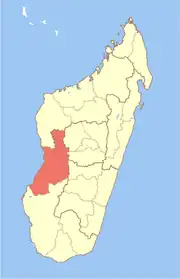 | |
| Mahabo (12) (615) | ||
| Manja (7) (616) | ||
| Miandrivazo (16) (617) | ||
| Morondava (6) (619) |
| |
5 districts; 57 communes | ||
This article is issued from Wikipedia. The text is licensed under Creative Commons - Attribution - Sharealike. Additional terms may apply for the media files.