For the rural municipality, see Manambolo (disambiguation)
| Manambolo | |
|---|---|
 | |
| Location | |
| Country | Madagascar |
| Region | Melaky, Bongolava |
| Physical characteristics | |
| Mouth | Indian Ocean |
• location | Soahazo, |
• coordinates | 19°15′10″S 44°20′00″E / 19.25278°S 44.33333°E |
• elevation | 0 m (0 ft) |
| Length | 370 km |
| Basin features | |
| Tributaries | |
| • left | Itondy River |
| • right | Bepoaka, Bebao, Andranobe, Manambolomaty, |
Manambolo River
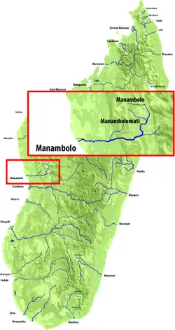
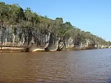
The Manambolo River is a river in the highlands of western Madagascar of 370 km. It crosses the Tsingy de Bemaraha Strict Nature Reserve and the Maningoza Reserve.[1]
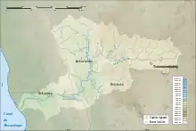
Manambolo river Bassin
The unpaved Route nationale 8 (Madagascar) crosses this river by ferry.
This river flies thru Tsiroanomandidy, Bekopaka, Ambakaka, Ankaramena, Ankavandra and Soaloka.
References
- ↑ "Maningoza Special Reserve". Madagaskar.com. Retrieved 26 October 2016.
This article is issued from Wikipedia. The text is licensed under Creative Commons - Attribution - Sharealike. Additional terms may apply for the media files.