Borač | |
|---|---|
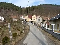 Western part of Borač | |
 Flag  Coat of arms | |
 Borač Location in the Czech Republic | |
| Coordinates: 49°24′3″N 16°21′40″E / 49.40083°N 16.36111°E | |
| Country | |
| Region | South Moravian |
| District | Brno-Country |
| First mentioned | 1368 |
| Area | |
| • Total | 5.91 km2 (2.28 sq mi) |
| Elevation | 279 m (915 ft) |
| Population (2023-01-01)[1] | |
| • Total | 354 |
| • Density | 60/km2 (160/sq mi) |
| Time zone | UTC+1 (CET) |
| • Summer (DST) | UTC+2 (CEST) |
| Postal code | 592 61 |
| Website | www |
Borač is a municipality and village in Brno-Country District in the South Moravian Region of the Czech Republic. It has about 400 inhabitants.
Administrative parts
The village of Podolí is an administrative part of Borač.
Demographics
| Year | Pop. | ±% |
|---|---|---|
| 1869 | 436 | — |
| 1880 | 469 | +7.6% |
| 1890 | 436 | −7.0% |
| 1900 | 405 | −7.1% |
| 1910 | 383 | −5.4% |
| 1921 | 394 | +2.9% |
| 1930 | 418 | +6.1% |
| 1950 | 427 | +2.2% |
| 1961 | 508 | +19.0% |
| 1970 | 404 | −20.5% |
| 1980 | 348 | −13.9% |
| 1991 | 317 | −8.9% |
| 2001 | 300 | −5.4% |
| 2011 | 342 | +14.0% |
| 2021 | 365 | +6.7% |
| Source: Censuses[2][3] | ||
References
- ↑ "Population of Municipalities – 1 January 2023". Czech Statistical Office. 2023-05-23.
- ↑ "Historický lexikon obcí České republiky 1869–2011 – Okres Brno-venkov" (in Czech). Czech Statistical Office. 2015-12-21.
- ↑ "Population Census 2021: Population by sex". Public Database. Czech Statistical Office. 2021-03-27.
Wikimedia Commons has media related to Borač.
This article is issued from Wikipedia. The text is licensed under Creative Commons - Attribution - Sharealike. Additional terms may apply for the media files.