Malhostovice | |
|---|---|
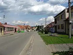 Centre of Malhostovice | |
 Flag  Coat of arms | |
 Malhostovice Location in the Czech Republic | |
| Coordinates: 49°20′1″N 16°30′8″E / 49.33361°N 16.50222°E | |
| Country | |
| Region | South Moravian |
| District | Brno-Country |
| First mentioned | 1320 |
| Area | |
| • Total | 11.51 km2 (4.44 sq mi) |
| Elevation | 279 m (915 ft) |
| Population (2023-01-01)[1] | |
| • Total | 982 |
| • Density | 85/km2 (220/sq mi) |
| Time zone | UTC+1 (CET) |
| • Summer (DST) | UTC+2 (CEST) |
| Postal code | 666 03 |
| Website | www |
Malhostovice is a municipality and village in Brno-Country District in the South Moravian Region of the Czech Republic. It has about 1,000 inhabitants.
Malhostovice lies approximately 17 kilometres (11 mi) north-west of Brno and 173 km (107 mi) south-east of Prague.
Administrative parts
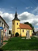
Church of Saint Lawrence
The village of Nuzířov is an administrative part of Malhostovice.
Demographics
As of the 2021 census, the population is 984, up 7% from 914 in 2011.
| Year | Pop. | ±% |
|---|---|---|
| 1869 | 822 | — |
| 1880 | 830 | +1.0% |
| 1890 | 868 | +4.6% |
| 1900 | 825 | −5.0% |
| 1910 | 908 | +10.1% |
| 1921 | 911 | +0.3% |
| 1930 | 968 | +6.3% |
| 1950 | 1,015 | +4.9% |
| 1961 | 1,037 | +2.2% |
| 1970 | 947 | −8.7% |
| 1980 | 888 | −6.2% |
| 1991 | 808 | −9.0% |
| 2001 | 828 | +2.5% |
| 2011 | 914 | +10.4% |
| 2021 | 984 | +7.7% |
| Source: Censuses[2][3] | ||
References
- ↑ "Population of Municipalities – 1 January 2023". Czech Statistical Office. 2023-05-23.
- ↑ "Historický lexikon obcí České republiky 1869–2011 – Okres Brno-venkov" (in Czech). Czech Statistical Office. 2015-12-21. pp. 1–2.
- ↑ "Population Census 2021: Population by sex". Public Database. Czech Statistical Office. 2021-03-27.
Wikimedia Commons has media related to Malhostovice.
This article is issued from Wikipedia. The text is licensed under Creative Commons - Attribution - Sharealike. Additional terms may apply for the media files.