Bray | |
|---|---|
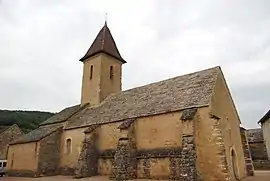 The church in Bray | |
Location of Bray | |
 Bray  Bray | |
| Coordinates: 46°30′15″N 4°43′19″E / 46.5042°N 4.7219°E | |
| Country | France |
| Region | Bourgogne-Franche-Comté |
| Department | Saône-et-Loire |
| Arrondissement | Mâcon |
| Canton | Cluny |
| Intercommunality | Clunisois |
| Area 1 | 9.89 km2 (3.82 sq mi) |
| Population | 124 |
| • Density | 13/km2 (32/sq mi) |
| Time zone | UTC+01:00 (CET) |
| • Summer (DST) | UTC+02:00 (CEST) |
| INSEE/Postal code | 71057 /71250 |
| Elevation | 209–475 m (686–1,558 ft) (avg. 270 m or 890 ft) |
| 1 French Land Register data, which excludes lakes, ponds, glaciers > 1 km2 (0.386 sq mi or 247 acres) and river estuaries. | |
Bray (French pronunciation: [bʁɛ] ⓘ) is a commune in the eastern French department of Saône-et-Loire.
Geography
The river Grosne forms the commune's western boundary.
See also
References
- ↑ "Populations légales 2021". The National Institute of Statistics and Economic Studies. 28 December 2023.
Wikimedia Commons has media related to Bray (Saône-et-Loire).
This article is issued from Wikipedia. The text is licensed under Creative Commons - Attribution - Sharealike. Additional terms may apply for the media files.