Coventry, Vermont | |
|---|---|
 Coventry  Coventry | |
| Coordinates: 44°51′57″N 72°15′53″W / 44.86583°N 72.26472°W | |
| Country | United States |
| State | Vermont |
| County | Orleans |
| Town | Coventry |
| Area | |
| • Total | 0.27 sq mi (0.71 km2) |
| • Land | 0.26 sq mi (0.68 km2) |
| • Water | 0.01 sq mi (0.03 km2) |
| Elevation | 720 ft (220 m) |
| Population | 111 |
| Time zone | UTC-5 (Eastern (EST)) |
| • Summer (DST) | UTC-4 (EDT) |
| ZIP Code | 05825 |
| Area code | 802 |
| FIPS code | 50-16075 |
| GNIS feature ID | 2586625[3] |
Coventry is the primary village and a census-designated place (CDP) in the town of Coventry, Orleans County, Vermont, United States. As of the 2020 census, it had a population of 111,[2] out of 1,100 in the entire town of Coventry.
The CDP is in north-central Orleans County, along the southern edge of the town of Coventry. It is bordered to the south by the town of Irasburg. U.S. Route 5 runs along the eastern edge of the community, leading north 6 miles (10 km) to Newport and southeast the same distance to Orleans. Vermont Route 14 follows US 5 along the eastern edge of Coventry, but leads north 7 miles (11 km) to Newport Center and south 6 miles (10 km) to Irasburg.
The Black River flows northward along the western edge of the village; it continues north to enter Lake Memphremagog at Newport.
References
- ↑ "2020 U.S. Gazetteer Files – Vermont". United States Census Bureau. Retrieved October 14, 2021.
- 1 2 "Coventry CDP, Vermont: 2020 DEC Redistricting Data (PL 94-171)". U.S. Census Bureau. Retrieved October 14, 2021.
- ↑ "Coventry Census Designated Place". Geographic Names Information System. United States Geological Survey, United States Department of the Interior.
Municipalities and communities of Orleans County, Vermont, United States | ||
|---|---|---|
| City | 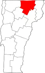 Map of Vermont highlighting Orleans County | |
| Towns | ||
| Villages | ||
| CDPs | ||
| Unincorporated communities | ||