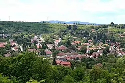
Csobánka | |
|---|---|
 Csobánka | |
 Coat of arms | |
 Csobánka | |
| Coordinates: 47°38′32.89″N 18°58′4.12″E / 47.6424694°N 18.9678111°E | |
| Country | |
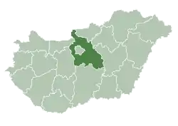
| County | Pest |
| Area | |
| • Total | 22.76 km2 (8.79 sq mi) |
| Population (2011) | |
| • Total | 3,175 |
| • Density | 122/km2 (320/sq mi) |
| Time zone | UTC+1 (CET) |
| • Summer (DST) | UTC+2 (CEST) |
| Postal code | 2014 |
| Area code | 26 |
Csobánka is a village in Pest County, Budapest metropolitan area, Hungary. Csobánka is located in the Pilis Mountains which is a National Park in Hungary.
The name Csobánka comes from Ottoman Turkish چوبان (çoban) rooted in < Persian چوبان (čubân). which means shepherd.[1] The word csobán originated from the settlement of the Magyars in Hungary. The earliest record of the official name was mentioned in a tax minute-book on January 3, 1698.
Twin towns – sister cities
 Wertheim, Germany (1992)
References
- ↑ "Magyar Keresztnevek Tára".
- ↑ "Szervezeti és Működési Szabályzata" (PDF). csobanka.hu (in Hungarian). Csobánka. November 2020. p. 19. Retrieved 2021-04-09.
External links
- Official website of Csobánka (in Hungarian)
| Towns (4) |
| |
|---|---|---|
| Large village (1) | ||
| Villages (8) | ||
This article is issued from Wikipedia. The text is licensed under Creative Commons - Attribution - Sharealike. Additional terms may apply for the media files.