Endrefalva | |
|---|---|
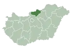
 Endrefalva Location of Endrefalva | |
| Coordinates: 48°07′40″N 19°34′24″E / 48.12785°N 19.57325°E | |
| Country | |
| County | Nógrád |
| Area | |
| • Total | 13.22 km2 (5.10 sq mi) |
| Population (2004) | |
| • Total | 1,273 |
| • Density | 96.29/km2 (249.4/sq mi) |
| Time zone | UTC+1 (CET) |
| • Summer (DST) | UTC+2 (CEST) |
| Postal code | 3165 |
| Area code | 32 |
Endrefalva is a village in Nógrád county, Hungary.
| Year | Population |
|---|---|
| 1870 | 868 |
| 1880 | 832 |
| 1890 | 952 |
| 1900 | 1076 |
| 1910 | 1121 |
| 1920 | 1210 |
| 1930 | 1337 |
| 1941 | 1353 |
| 1949 | 1414 |
| 1960 | 1501 |
| 1970 | 1516 |
| 1980 | 1348 |
| 1990 | 1235 |
| 2001 | 1207 |
| 2011 | 1270 |
References
- ↑ "Nógrád county - Data on localities - Population number, population density". Hungarian Central Statistical Office/Központi Statisztikai Hivatal. Retrieved 2021-05-22.
External links
- Street map (in Hungarian)
This article is issued from Wikipedia. The text is licensed under Creative Commons - Attribution - Sharealike. Additional terms may apply for the media files.