Szarvasgede | |
|---|---|
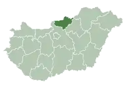
 Szarvasgede Location of Szarvasgede | |
| Coordinates: 47°49′17″N 19°38′19″E / 47.82147°N 19.63851°E | |
| Country | |
| County | Nógrád |
| Area | |
| • Total | 9.99 km2 (3.86 sq mi) |
| Population (2004) | |
| • Total | 440 |
| • Density | 44.04/km2 (114.1/sq mi) |
| Time zone | UTC+1 (CET) |
| • Summer (DST) | UTC+2 (CEST) |
| Postal code | 3051 |
| Area code | 32 |
External links
- Street map (in Hungarian)
This article is issued from Wikipedia. The text is licensed under Creative Commons - Attribution - Sharealike. Additional terms may apply for the media files.