Engenheiro Coelho | |
|---|---|
Municipality | |
 Flag  Coat of arms | |
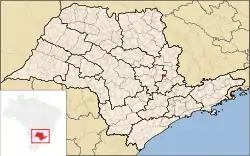 Location in São Paulo state | |
 Engenheiro Coelho Location in Brazil | |
| Coordinates: 22°29′18″S 47°12′54″W / 22.48833°S 47.21500°W | |
| Country | |
| Region | Southeast Brazil |
| State | São Paulo |
| Metropolitan Region | Campinas |
| Government | |
| • Prefect | Pedro Franco de Oliveira (2017 – 2020) (PMDB) |
| Area | |
| • Total | 109.94 km2 (42.45 sq mi) |
| Elevation | 655 m (2,149 ft) |
| Population (2020 [1]) | |
| • Total | 21,249 |
| • Density | 190/km2 (500/sq mi) |
| Time zone | UTC−3 (BRT) |
| Postal code | 13165-000 |
| Phone code | 19 |
Engenheiro Coelho is a municipality in the east of the State of São Paulo, Brazil. It is part of the Metropolitan Region of Campinas.[2] The population is 21,249 (2020 est.) in an area of 109.94 km².[3] It is located about 158 km (98 mi) from São Paulo and 900 km (560 mi) from Brasília. Engenheiro Coelho was founded on May 19, 1991, from a rural community, therefore, it has kept an agricultural economy mainly based on the cultivation of orange, sugarcane, and cassava.
Education
- UNASP (Adventist University of São Paulo), which offers many courses from Elementary School to University.
References
This article is issued from Wikipedia. The text is licensed under Creative Commons - Attribution - Sharealike. Additional terms may apply for the media files.