Fornells de la Selva | |
|---|---|
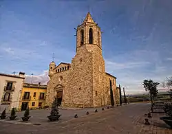 Church of St. Cugat | |
 Flag  Coat of arms | |
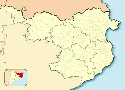 Fornells de la Selva Location in Catalonia  Fornells de la Selva Fornells de la Selva (Spain) | |
| Coordinates: 41°56′N 2°49′E / 41.933°N 2.817°E | |
| Country | |
| Community | |
| Province | Girona |
| Comarca | Gironès |
| Government | |
| • mayor | Narcís Boschdemont Esparraguera (2015)[1] |
| Area | |
| • Total | 11.9 km2 (4.6 sq mi) |
| Elevation | 102 m (335 ft) |
| Population (2018)[3] | |
| • Total | 2,649 |
| • Density | 220/km2 (580/sq mi) |
| Demonym(s) | Fornellenc, fornellenca |
| Website | www |
Fornells de la Selva is a municipality in the comarca of Gironès that forms part of the urban area of Girona.
The northern boundary is with the municipality of Girona; the southern is with Riudellots de la Selva and Campllong; the east with Quart and Llambilles; and the west with Vilablareix and Aiguaviva. The municipality covers an area of 11.88 square kilometres (4.59 sq mi) and the population in 2014 was 2,479.[2]
Transportation
Fornells de la Selva is located 7 km south of Girona via the N-IIa. It also has its own railway station (with ticket sales currently closed) which is served by Renfe's Regional line from Barcelona and to Portbou. It is also 5 km from the Girona-Costa Brava Airport.
References
- ↑ "Ajuntament de Fornells de la Selva". Generalitat of Catalonia. Retrieved 2015-11-13.
- 1 2 "El municipi en xifres: Fornells de la Selva". Statistical Institute of Catalonia. Retrieved 2015-11-23.
- ↑ Municipal Register of Spain 2018. National Statistics Institute.
External links
- Government data pages (in Catalan)
Places adjacent to Fornells de la Selva | ||||||||||||||||
|---|---|---|---|---|---|---|---|---|---|---|---|---|---|---|---|---|
| ||||||||||||||||
This article is issued from Wikipedia. The text is licensed under Creative Commons - Attribution - Sharealike. Additional terms may apply for the media files.