Guils de Cerdanya | |
|---|---|
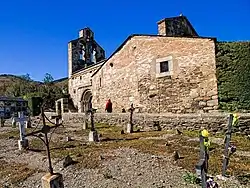 Church of Sant Esteve. | |
 Flag  Coat of arms | |
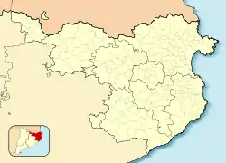 Guils de Cerdanya Location in Catalonia  Guils de Cerdanya Guils de Cerdanya (Spain) | |
| Coordinates: 42°27′2″N 1°52′47″E / 42.45056°N 1.87972°E | |
| Country | |
| Autonomous community | |
| Province | Girona |
| Comarca | Cerdanya |
| Government | |
| • Mayor | Valentí Tuset Creus (2015)[1] |
| Area | |
| • Total | 22.0 km2 (8.5 sq mi) |
| Elevation | 1,385 m (4,544 ft) |
| Population (2018)[3] | |
| • Total | 529 |
| • Density | 24/km2 (62/sq mi) |
| Demonym | Guilsenc |
| Time zone | UTC+1 (CET) |
| • Summer (DST) | UTC+2 (CEST) |
| Postal code | 17528 |
| Official language(s) | Catalan, Spanish |
| Website | guils |
Guils de Cerdanya is a municipality in the comarca of Cerdanya, province of Girona, Catalonia, Spain.
Attractions include the Romanesque church of Sant Esteven (12th century).
References
- ↑ "Ajuntament de Guils de Cerdanya". Generalitat of Catalonia. Retrieved 2015-11-13.
- ↑ "El municipi en xifres: Guils de Cerdanya". Statistical Institute of Catalonia. Retrieved 2015-11-23.
- ↑ Municipal Register of Spain 2018. National Statistics Institute.
External links
- Government data pages (in Catalan)
Places adjacent to Guils de Cerdanya | |
|---|---|
This article is issued from Wikipedia. The text is licensed under Creative Commons - Attribution - Sharealike. Additional terms may apply for the media files.