Fresles | |
|---|---|
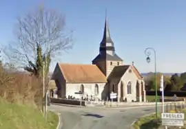 The church in Fresles | |
Location of Fresles | |
 Fresles  Fresles | |
| Coordinates: 49°44′39″N 1°20′56″E / 49.7442°N 1.3489°E | |
| Country | France |
| Region | Normandy |
| Department | Seine-Maritime |
| Arrondissement | Dieppe |
| Canton | Neufchâtel-en-Bray |
| Intercommunality | CC Bray-Eawy |
| Government | |
| • Mayor (2020–2026) | Patrick Lévêque[1] |
| Area 1 | 10.96 km2 (4.23 sq mi) |
| Population | 237 |
| • Density | 22/km2 (56/sq mi) |
| Time zone | UTC+01:00 (CET) |
| • Summer (DST) | UTC+02:00 (CEST) |
| INSEE/Postal code | 76283 /76270 |
| Elevation | 66–220 m (217–722 ft) (avg. 119 m or 390 ft) |
| 1 French Land Register data, which excludes lakes, ponds, glaciers > 1 km2 (0.386 sq mi or 247 acres) and river estuaries. | |
Fresles (French pronunciation: [fʁɛl]) is a commune in the Seine-Maritime department in the Normandy region in northern France.
Geography
A small farming village situated in the Pays de Bray, some 22 miles (35 km) southeast of Dieppe, at the junction of the D97 and the D114 roads.
Population
| Year | Pop. | ±% p.a. |
|---|---|---|
| 1968 | 186 | — |
| 1975 | 173 | −1.03% |
| 1982 | 151 | −1.92% |
| 1990 | 166 | +1.19% |
| 1999 | 147 | −1.34% |
| 2007 | 213 | +4.74% |
| 2012 | 238 | +2.24% |
| 2017 | 236 | −0.17% |
| Source: INSEE[3] | ||
Places of interest
- The thirteenth century church of Notre-Dame.
See also
References
- ↑ "Répertoire national des élus: les maires" (in French). data.gouv.fr, Plateforme ouverte des données publiques françaises. 13 September 2022.
- ↑ "Populations légales 2021". The National Institute of Statistics and Economic Studies. 28 December 2023.
- ↑ Population en historique depuis 1968, INSEE
Wikimedia Commons has media related to Fresles.
This article is issued from Wikipedia. The text is licensed under Creative Commons - Attribution - Sharealike. Additional terms may apply for the media files.