Gedersdorf | |
|---|---|
 | |
 Coat of arms | |
 Gedersdorf Location within Austria | |
| Coordinates: 48°26′N 15°41′E / 48.433°N 15.683°E | |
| Country | Austria |
| State | Lower Austria |
| District | Krems-Land |
| Government | |
| • Mayor | Franz Brandl (ÖVP) |
| Area | |
| • Total | 18.83 km2 (7.27 sq mi) |
| Elevation | 194 m (636 ft) |
| Population (2018-01-01)[2] | |
| • Total | 2,184 |
| • Density | 120/km2 (300/sq mi) |
| Time zone | UTC+1 (CET) |
| • Summer (DST) | UTC+2 (CEST) |
| Postal code | 3494 |
| Area code | 02735 |
| Website | www.gedersdorf.at |
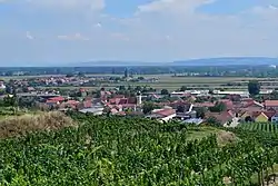
Gedersdorf is a municipality in the district of Krems-Land in the Austrian state of Lower Austria.
Geography
The municipality consists of seven villages: Altweidling, Brunn im Felde, Donaudorf, Gedersdorf, Schlickendorf, Stratzdorf, and Theiß.
History
It was formed in 1967 by the merger of three smaller municipalities.
References
- ↑ "Dauersiedlungsraum der Gemeinden Politischen Bezirke und Bundesländer - Gebietsstand 1.1.2018". Statistics Austria. Retrieved 10 March 2019.
- ↑ "Einwohnerzahl 1.1.2018 nach Gemeinden mit Status, Gebietsstand 1.1.2018". Statistics Austria. Retrieved 9 March 2019.

This article is issued from Wikipedia. The text is licensed under Creative Commons - Attribution - Sharealike. Additional terms may apply for the media files.