Hofamt Priel | |
|---|---|
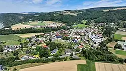 Aerial view of Hofamt Priel | |
 Coat of arms | |
 Hofamt Priel Location within Austria | |
| Coordinates: 48°11′44″N 15°4′44″E / 48.19556°N 15.07889°E | |
| Country | Austria |
| State | Lower Austria |
| District | Melk |
| Government | |
| • Mayor | Friedrich Buchberger |
| Area | |
| • Total | 39.63 km2 (15.30 sq mi) |
| Elevation | 240 m (790 ft) |
| Population (2018-01-01)[2] | |
| • Total | 1,675 |
| • Density | 42/km2 (110/sq mi) |
| Time zone | UTC+1 (CET) |
| • Summer (DST) | UTC+2 (CEST) |
| Postal code | 3681 |
| Area code | +43 7412 |
| Website | www.hofamtpriel.at |
Hofamt Priel is a municipality in the district of Melk in the Austrian state of Lower Austria north of the river Danube. On the night of 2 May 1945, the SS marched more than 200 refugees a short way inland and murdered them.[3]
Population
| Year | Pop. | ±% |
|---|---|---|
| 1971 | 1,463 | — |
| 1981 | 1,604 | +9.6% |
| 1991 | 1,624 | +1.2% |
| 2001 | 1,648 | +1.5% |
References
- ↑ "Dauersiedlungsraum der Gemeinden Politischen Bezirke und Bundesländer - Gebietsstand 1.1.2018". Statistics Austria. Retrieved 10 March 2019.
- ↑ "Einwohnerzahl 1.1.2018 nach Gemeinden mit Status, Gebietsstand 1.1.2018". Statistics Austria. Retrieved 9 March 2019.
- ↑ Hoad, Phil (2023-04-24). "Endphase review – searing testimony to one of the last Nazi war crimes". The Guardian. ISSN 0261-3077. Retrieved 2023-05-05.
This article is issued from Wikipedia. The text is licensed under Creative Commons - Attribution - Sharealike. Additional terms may apply for the media files.