Ingersheim | |
|---|---|
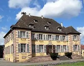 The town hall in Ingersheim | |
 Coat of arms | |
Location of Ingersheim | |
 Ingersheim  Ingersheim | |
| Coordinates: 48°05′43″N 7°18′25″E / 48.0953°N 7.3069°E | |
| Country | France |
| Region | Grand Est |
| Department | Haut-Rhin |
| Arrondissement | Colmar-Ribeauvillé |
| Canton | Colmar-1 |
| Intercommunality | Colmar Agglomération |
| Government | |
| • Mayor (2020–2026) | Denise Stoeckle[1] |
| Area 1 | 7.44 km2 (2.87 sq mi) |
| Population | 4,711 |
| • Density | 630/km2 (1,600/sq mi) |
| Time zone | UTC+01:00 (CET) |
| • Summer (DST) | UTC+02:00 (CEST) |
| INSEE/Postal code | 68155 /68040 |
| Elevation | 196–326 m (643–1,070 ft) (avg. 215 m or 705 ft) |
| 1 French Land Register data, which excludes lakes, ponds, glaciers > 1 km2 (0.386 sq mi or 247 acres) and river estuaries. | |
Ingersheim (French pronunciation: [iŋ(ɡ)əʁsaim] ⓘ) is a commune in the Haut-Rhin department in Grand Est in north-eastern France. It is located near Colmar.
Population
| Year | Pop. | ±% p.a. |
|---|---|---|
| 1968 | 3,636 | — |
| 1975 | 4,466 | +2.98% |
| 1982 | 4,271 | −0.64% |
| 1990 | 4,063 | −0.62% |
| 1999 | 4,170 | +0.29% |
| 2007 | 4,583 | +1.19% |
| 2012 | 4,621 | +0.17% |
| 2017 | 4,678 | +0.25% |
| Source: INSEE[3] | ||
See also
References
- ↑ "Répertoire national des élus: les maires". data.gouv.fr, Plateforme ouverte des données publiques françaises (in French). 2 December 2020.
- ↑ "Populations légales 2021". The National Institute of Statistics and Economic Studies. 28 December 2023.
- ↑ Population en historique depuis 1968, INSEE
Wikimedia Commons has media related to Ingersheim (Haut-Rhin).
This article is issued from Wikipedia. The text is licensed under Creative Commons - Attribution - Sharealike. Additional terms may apply for the media files.