La Flamengrie | |
|---|---|
.JPG.webp) A general view of La Flamengrie | |
.svg.png.webp) Coat of arms | |
Location of La Flamengrie | |
 La Flamengrie  La Flamengrie | |
| Coordinates: 50°18′58″N 3°43′02″E / 50.3161°N 3.7172°E | |
| Country | France |
| Region | Hauts-de-France |
| Department | Nord |
| Arrondissement | Avesnes-sur-Helpe |
| Canton | Aulnoye-Aymeries |
| Intercommunality | CC Pays de Mormal |
| Government | |
| • Mayor (2020–2026) | Yohan Lecerf[1] |
| Area 1 | 2.03 km2 (0.78 sq mi) |
| Population | 435 |
| • Density | 210/km2 (550/sq mi) |
| Time zone | UTC+01:00 (CET) |
| • Summer (DST) | UTC+02:00 (CEST) |
| INSEE/Postal code | 59232 /59570 |
| Elevation | 108–132 m (354–433 ft) (avg. 120 m or 390 ft) |
| 1 French Land Register data, which excludes lakes, ponds, glaciers > 1 km2 (0.386 sq mi or 247 acres) and river estuaries. | |
La Flamengrie (French pronunciation: [la flamɑ̃ɡʁi]) is a commune in the Nord department in northern France.[3]
Heraldry
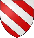 Arms of La Flamengrie |
The arms of La Flamengrie are blazoned : Bendy argent and gules. (La Flamengrie, Fournes-en-Weppes and Wargnies-le-Grand use the same arms.)
|
See also
References
- ↑ "Répertoire national des élus: les maires" (in French). data.gouv.fr, Plateforme ouverte des données publiques françaises. 13 September 2022.
- ↑ "Populations légales 2021". The National Institute of Statistics and Economic Studies. 28 December 2023.
- ↑ INSEE commune file
Wikimedia Commons has media related to La Flamengrie (Nord).
This article is issued from Wikipedia. The text is licensed under Creative Commons - Attribution - Sharealike. Additional terms may apply for the media files.