Laneuville-à-Rémy | |
|---|---|
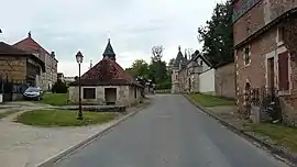 The centre of Laneuville-à-Rémy | |
Location of Laneuville-à-Rémy | |
 Laneuville-à-Rémy  Laneuville-à-Rémy | |
| Coordinates: 48°28′32″N 4°53′16″E / 48.4756°N 4.8877°E | |
| Country | France |
| Region | Grand Est |
| Department | Haute-Marne |
| Arrondissement | Saint-Dizier |
| Canton | Wassy |
| Intercommunality | CA Saint-Dizier Der et Blaise |
| Area 1 | 6.0 km2 (2.3 sq mi) |
| Population | 65 |
| • Density | 11/km2 (28/sq mi) |
| Time zone | UTC+01:00 (CET) |
| • Summer (DST) | UTC+02:00 (CEST) |
| INSEE/Postal code | 52266 /52220 |
| 1 French Land Register data, which excludes lakes, ponds, glaciers > 1 km2 (0.386 sq mi or 247 acres) and river estuaries. | |
Laneuville-à-Rémy (French pronunciation: [lanøvil a ʁemi]) is a commune in the Haute-Marne department in north-eastern France. Between 1972 and 2012 it was part of the commune Robert-Magny-Laneuville-à-Rémy.
See also
References
Wikimedia Commons has media related to Laneuville-à-Rémy.
- ↑ "Populations légales 2021". The National Institute of Statistics and Economic Studies. 28 December 2023.
This article is issued from Wikipedia. The text is licensed under Creative Commons - Attribution - Sharealike. Additional terms may apply for the media files.