Les Bayards | |
|---|---|
 Coat of arms | |
Location of Les Bayards | |
 Les Bayards  Les Bayards | |
| Coordinates: 46°55′N 6°31′E / 46.917°N 6.517°E | |
| Country | Switzerland |
| Canton | Neuchâtel |
| District | Val-de-Travers |
| Area | |
| • Total | 19.15 km2 (7.39 sq mi) |
| Elevation | 980 m (3,220 ft) |
| Population (December 2005) | |
| • Total | 370 |
| • Density | 19/km2 (50/sq mi) |
| Time zone | UTC+01:00 (Central European Time) |
| • Summer (DST) | UTC+02:00 (Central European Summer Time) |
| Postal code(s) | 2127 |
| SFOS number | 6501 |
| Surrounded by | Buttes, Hauterive-la-Fresse (FR-25), La Brévine, Les Alliés (FR-25), Les Verrières, Saint-Sulpice |
| Website | www SFSO statistics |
Les Bayards was a municipality in the district of Val-de-Travers in the canton of Neuchâtel in Switzerland. On 1 January 2009, the former municipalities of Boveresse, Buttes, Couvet, Fleurier, Les Bayards, Môtiers, Noiraigue, Saint-Sulpice and Travers merged to form Val-de-Travers.[1]
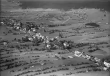
Aerial view (1950)
References
- ↑ Amtliches Gemeindeverzeichnis der Schweiz published by the Swiss Federal Statistical Office (in German) accessed 14 January 2010
External links
- Les Bayards in German, French and Italian in the online Historical Dictionary of Switzerland.
This article is issued from Wikipedia. The text is licensed under Creative Commons - Attribution - Sharealike. Additional terms may apply for the media files.