Malé Lednice | |
|---|---|
Municipality | |
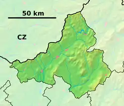 Malé Lednice Location of Malé Lednice in the Trenčín Region  Malé Lednice Malé Lednice (Slovakia) | |
| Coordinates: 49°04′N 18°34′E / 49.067°N 18.567°E | |
| Country | Slovakia |
| Region | Trenčín |
| District | Považská Bystrica |
| First mentioned | 1339 |
| Area | |
| • Total | 5.105 km2 (1.971 sq mi) |
| Elevation | 425 m (1,394 ft) |
| Population | |
| • Total | 528 |
| • Density | 100/km2 (270/sq mi) |
| Postal code | 018 16 (pošta Domaniža) |
| Area code | 421-42 |
| Car plate | PB |
| Website | www.malelednice.sk |
Malé Lednice (Hungarian: Kislednic) is a village and municipality in Považská Bystrica District in the Trenčín Region of north-western Slovakia.
History
In historical records the village was first mentioned in 1339.
Geography
The municipality lies at an altitude of 425 metres and covers an area of 15.105 km². It has a population of about 528 people.
External links
- Official website

- https://web.archive.org/web/20070513023228/http://www.statistics.sk/mosmis/eng/run.html
Municipalities of Považská Bystrica District | ||
|---|---|---|
This article is issued from Wikipedia. The text is licensed under Creative Commons - Attribution - Sharealike. Additional terms may apply for the media files.