| Maramataha River | |
|---|---|
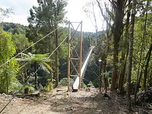 Maramataha suspension bridge carrying the Timber Trail over the Maramataha River | |
| Native name | Maramataha (Māori) |
| Location | |
| Country | New Zealand |
| Region | Manawatū-Whanganui |
| District | Ruapehu |
| Physical characteristics | |
| Source | Hauhungaroa Range |
| • location | Pureora Forest Park |
| • coordinates | 38°39′7″S 175°34′41″E / 38.65194°S 175.57806°E |
| • elevation | 900 m (3,000 ft) |
| Mouth | Ongarue River |
• coordinates | 38°39′14″S 175°18′58″E / 38.65389°S 175.31611°E |
• elevation | 190 m (620 ft) |
| Length | 39 km (24 mi) |
| Basin features | |
| Progression | Maramataha River → Ongarue River → Whanganui River |
| River system | Whanganui River |
The Maramataha River is a river in the Manawatū-Whanganui region of New Zealand. The river rises west of Lake Taupō and flows generally west to become a tributary of the Ongarue River.[1]
See also
References
- ↑ "Place name detail: Maramataha River". New Zealand Gazetteer. New Zealand Geographic Board. Retrieved 23 April 2010.
This article is issued from Wikipedia. The text is licensed under Creative Commons - Attribution - Sharealike. Additional terms may apply for the media files.