Milo, Oklahoma | |
|---|---|
 Milo Location within the state of Oklahoma  Milo Milo (the United States) | |
| Coordinates: 34°19′57″N 97°20′22″W / 34.33250°N 97.33944°W | |
| Country | United States |
| State | Oklahoma |
| County | Carter |
| Elevation | 892 ft (272 m) |
| Time zone | UTC-6 (Central (CST)) |
| • Summer (DST) | UTC-5 (CDT) |
| ZIP codes | 73401 |
| GNIS feature ID | 1095425[1] |
Milo is a community located in Carter County, Oklahoma, United States.[1] It is on State Highway 53, south of the Arbuckles. The post office opened October 28, 1899.[2] It was later closed. The current ZIP Code is 73458 assigned to Springer. Milo is said to have been a portmanteau of the initials of the four daughters of resident J.W. Johnson.[2]
References
Municipalities and communities of Carter County, Oklahoma, United States | ||
|---|---|---|
| Cities | 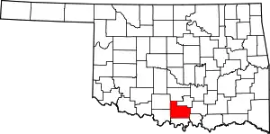 Carter County map | |
| Towns | ||
| CDP | ||
| Other communities | ||
| Ghost towns | ||
| Indian reservation | ||
| Footnotes | ‡This populated place also has portions in an adjacent county or counties | |
This article is issued from Wikipedia. The text is licensed under Creative Commons - Attribution - Sharealike. Additional terms may apply for the media files.