Monforte | |
|---|---|
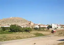
| Monforte de Moyuela | |
 | |
 Flag  Coat of arms | |
 Monforte Location in Spain | |
| Coordinates: 41°3′N 1°1′W / 41.050°N 1.017°W | |
| Country | |
| Autonomous community | |
| Province | Teruel |
| Comarca | Jiloca |
| Government | |
| • Alcalde | Paula Delmás Biel (2019) |
| Area | |
| • Total | 47.74 km2 (18.43 sq mi) |
| Elevation | 1,008 m (3,307 ft) |
| Population (2018)[1] | |
| • Total | 65 |
| • Density | 1.4/km2 (3.5/sq mi) |
| Demonym(s) | Monfortino (in Spanish) Montfortino (in Aragonese) |
| Time zone | UTC+1 (CET) |
| • Summer (DST) | UTC+2 (CEST) |
| Postal code | 44493 |
| Dialing code | (+34) 978 73... |
| Website | www |
Monforte de Moyuela is a town and municipality in Aragon, located in the comarca of Jiloca, in the province of Teruel. According to the 2005 census (INE), the municipality has a population of 76 inhabitants, with an area of 47.77 km² and a density of 1.58.
The municipality is 121 kilometres from Teruel, the provincial capital.
References
- ↑ Municipal Register of Spain 2018. National Statistics Institute.
Wikimedia Commons has media related to Monforte de Moyuela.
This article is issued from Wikipedia. The text is licensed under Creative Commons - Attribution - Sharealike. Additional terms may apply for the media files.