Flag
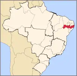
Moreno is a city in the state of Pernambuco, Brazil. It's integrated in the Recife metropolitan area with another 13 cities. Moreno has a total area of 195.6 square kilometers and had an estimated population of 63,294 inhabitants in 2020 according with IBGE.[1]
Geography
- State - Pernambuco
- Region - RMR (Recife)
- Boundaries - São Lourenço da Mata (N), Cabo de Santo Agostinho (S), Jaboatão (W), Vitória de Santo Antão (E)
- Area - 195.6 km2
- Elevation - 96 m (312 ft)
- Hydrography - Capibaribe River
- Vegetation - Atlantic forest, capoeira, capoeirinha and sugarcane plantation
- Climate - Hot tropical and dry
- Annual average temperature - 26 C
- Main road - BR 232 and PE 007
- Distance to Recife - 30 km
Economy
The main economic activities in Moreno are based in food industry, commerce and primary sector especially eggs, chickens and honey.
Economic Indicators
| Population | GDP x(1000 R$).[2] | GDP pc (R$) | PE | RMR |
|---|---|---|---|---|
| 55.659 | 207.508 | 3.928 | 0.35% | 0.54% |
Economy by Sector 2006
| Primary sector | Secondary sector | Service sector |
|---|---|---|
| 17.76% | 14.42% | 67.82% |
Health Indicators
| HDI (2000) | Hospitals (2007) | Hospitals beds (2007) | Children's Mortality every 1000 (2005) |
|---|---|---|---|
| 0.693 | 2 | 123 | 20.4 |
References
Capital: Recife | ||||||||||||||
| Mesoregion Agreste Pernambucano |
|  | ||||||||||||
| Mesoregion Mata Pernambucana |
| |||||||||||||
| Mesoregion Metropolitana de Recife |
| |||||||||||||
| Mesoregion Sao Francisco Pernambucano |
| |||||||||||||
| Mesoregion Sertão Pernambucano |
| |||||||||||||
8°07′07″S 35°05′32″W / 8.11861°S 35.09222°W
This article is issued from Wikipedia. The text is licensed under Creative Commons - Attribution - Sharealike. Additional terms may apply for the media files.