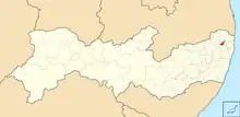
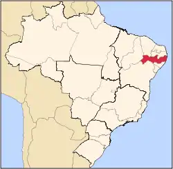
Tracunhaém is a city located in the state of Pernambuco, Brazil. Located at 63 km from Recife, capital of the state of Pernambuco. Has an estimated (IBGE 2020) population of 13,813 inhabitants.[1]
Geography
- State - Pernambuco
- Region - Zona da mata Pernambucana
- Boundaries - Nazaré da Mata (N); Paudalho (S); Araçoiaba and Itaquitinga (E); Carpina (W)
- Area - 116.66 km2
- Elevation - 120 m
- Hydrography - Goiana and Capibaribe rivers
- Vegetation - Subcaducifólia forest
- Climate - Hot tropical and humid
- Annual average temperature - 24.9 c
- Distance to Recife - 63 km
Economy
The main economic activities in Tracunhaém are based in commerce and agribusiness, especially sugarcane; and livestock such as poultry, cattle and pigs.
Economic indicators
| Population[2] | GDP x(1000 R$).[3] | GDP pc (R$) | PE |
|---|---|---|---|
| 13.265 | 46.591 | 3.659 | 0.08% |
Economy by Sector 2006
| Primary sector | Secondary sector | Service sector |
|---|---|---|
| 32.82% | 6.87% | 60.31% |
Health indicators
| HDI (2000) | Hospitals (2007) | Hospitals beds (2007) | Children's Mortality every 1000 (2005) |
|---|---|---|---|
| 0.636 | 1 | 17 | 12.8 |
References
- ↑ IBGE 2020
- ↑ http://www.ibge.gov.br/home/estatistica/populacao/estimativa2009/POP2009_DOU.pdf IBGE Population 2009 Tracunhaém, page 35]
- ↑ Tracunhaém 2007 GDP IBGE pag 32 Archived 2016-03-04 at the Wayback Machine
- ↑ PE State site - City by city profile
Capital: Recife | ||||||||||||||
| Mesoregion Agreste Pernambucano |
|  | ||||||||||||
| Mesoregion Mata Pernambucana |
| |||||||||||||
| Mesoregion Metropolitana de Recife |
| |||||||||||||
| Mesoregion Sao Francisco Pernambucano |
| |||||||||||||
| Mesoregion Sertão Pernambucano |
| |||||||||||||
7°48′18″S 35°14′24″W / 7.80500°S 35.24000°W
This article is issued from Wikipedia. The text is licensed under Creative Commons - Attribution - Sharealike. Additional terms may apply for the media files.