Mossy Bottom | |
|---|---|
Home Rule-Class | |
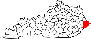
 Mossy Bottom Location within the state of Kentucky  Mossy Bottom Mossy Bottom (the United States) | |
| Coordinates: 37°31′48″N 82°34′46″W / 37.53000°N 82.57944°W | |
| Country | United States |
| State | Kentucky |
| County | Pike |
| Government | |
| • Type | Commission |
| Elevation | 656 ft (200 m) |
| Time zone | UTC-5 (Eastern (EST)) |
| • Summer (DST) | UTC-4 (EST) |
| ZIP codes | 41501 |
| GNIS feature ID | 498674[1] |
Mossy Bottom is part of Coal Run Village in Pike County, Kentucky, United States.
References
This article is issued from Wikipedia. The text is licensed under Creative Commons - Attribution - Sharealike. Additional terms may apply for the media files.