Myra | |
|---|---|
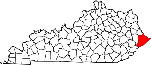
 Myra Location within the state of Kentucky  Myra Myra (the United States) | |
| Coordinates: 37°17′23″N 82°36′00″W / 37.28972°N 82.60000°W | |
| Country | United States |
| State | Kentucky |
| County | Pike |
| Elevation | 961 ft (293 m) |
| Time zone | UTC-5 (Eastern (EST)) |
| • Summer (DST) | UTC-4 (EDT) |
| ZIP codes | 41549 |
| GNIS feature ID | 508667[1] |
Myra is an unincorporated community located in Pike County, Kentucky, United States.
References
This article is issued from Wikipedia. The text is licensed under Creative Commons - Attribution - Sharealike. Additional terms may apply for the media files.