Municipality of Kanal ob Soči
Občina Kanal ob Soči | |
|---|---|
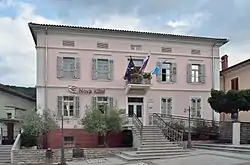 Town hall | |
 Coat of arms | |
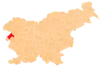
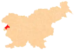 Location of the Municipality of Kanal ob Soči in Slovenia | |
| Coordinates: 46°05′N 13°38′E / 46.083°N 13.633°E | |
| Country | |
| Government | |
| • Mayor | Miha Stegel |
| Area | |
| • Total | 146.5 km2 (56.6 sq mi) |
| Population (2016)[1] | |
| • Total | 5,386 |
| • Density | 37/km2 (95/sq mi) |
| Time zone | UTC+01 (CET) |
| • Summer (DST) | UTC+02 (CEST) |
| Website | www |
The Municipality of Kanal ob Soči (pronounced [kaˈnaːl ɔp ˈsoːtʃi] or [kaˈnaːu̯ ɔp ˈsoːtʃi]; Slovene: Občina Kanal ob Soči) is a municipality in the traditional region of the Littoral in western Slovenia. The seat of the municipality is the town of Kanal. Kanal ob Soči became a municipality in 1994.[2]
Settlements
In addition to the municipal seat of Kanal, the municipality also includes the following settlements:
- Ajba
- Anhovo
- Avče
- Bodrež
- Čolnica
- Deskle
- Doblar
- Dolenje Nekovo
- Goljevica
- Gorenja Vas
- Gorenje Nekovo
- Gorenje Polje
- Jesen
- Kal nad Kanalom
- Kambreško
- Kamenca nad Ložicami
- Kanalski Vrh
- Krstenica
- Levpa
- Lig
- Ložice
- Močila
- Morsko
- Paljevo
- Plave
- Prilesje pri Plavah
- Ravna
- Robidni Breg
- Ročinj
- Seniški Breg
- Ukanje
- Zagomila
- Zagora
- Zapotok
References
- 1 2 "Občina Kanal". Statistični urad Republike Slovenije. Retrieved February 8, 2020.
- ↑ "Občina". Občina Kanal ob Soči. Retrieved February 8, 2020.
External links
 Media related to Municipality of Kanal at Wikimedia Commons
- Municipality of Kanal ob Soči on Geopedia
- Kanal ob Soči municipal site
Places adjacent to Municipality of Kanal ob Soči | |
|---|---|
| Settlements | Administrative seat: Kanal
|  | ||||
|---|---|---|---|---|---|---|
| Landmarks |
| |||||
| Notable people |
| |||||
This article is issued from Wikipedia. The text is licensed under Creative Commons - Attribution - Sharealike. Additional terms may apply for the media files.