Municipality of Žalec
Občina Žalec | |
|---|---|
 | |
 Coat of arms | |
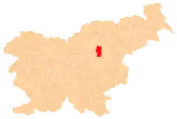 Location of the Municipality of Žalec in Slovenia | |
| Coordinates: 46°15′40″N 15°9′40″E / 46.26111°N 15.16111°E | |
| Country | |
| Government | |
| • Mayor | Janko Kos |
| Area | |
| • Total | 117.1 km2 (45.2 sq mi) |
| Population (2002)[1] | |
| • Total | 20,335 |
| • Density | 170/km2 (450/sq mi) |
| Time zone | UTC+01 (CET) |
| • Summer (DST) | UTC+02 (CEST) |
| Website | www |
The Municipality of Žalec (pronounced [ˈʒaːləts] ⓘ; Slovene: Občina Žalec) is a municipality in Slovenia in the traditional region of Styria. The seat of the municipality is the town of Žalec.[2] The municipality was established in its current form on 7 August 1998, when the former larger municipality of Žalec was divided into six smaller municipalities.[3]
Settlements
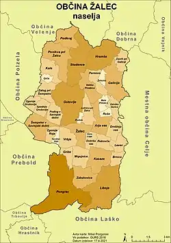
Villages in the municipality
In addition to the municipal seat of Žalec, the municipality also includes the following settlements:
- Arja Vas
- Brnica
- Dobriša Vas
- Drešinja Vas
- Galicija
- Gotovlje
- Grče
- Griže
- Hramše
- Kale
- Kasaze
- Levec
- Liboje
- Ložnica pri Žalcu
- Mala Pirešica
- Migojnice
- Novo Celje
- Pernovo
- Petrovče
- Podkraj
- Podlog v Savinjski Dolini
- Podvin
- Pongrac
- Ponikva pri Žalcu
- Ruše
- Šempeter v Savinjski Dolini
- Spodnje Grušovlje
- Spodnje Roje
- Studence
- Velika Pirešica
- Vrbje
- Zabukovica
- Zalog pri Šempetru
- Zaloška Gorica
- Zavrh pri Galiciji
- Železno
- Zgornje Grušovlje
- Zgornje Roje
References
External links
 Media related to Municipality of Žalec at Wikimedia Commons
- Municipality of Žalec on Geopedia
- Municipality of Žalec website
Places adjacent to Municipality of Žalec | |
|---|---|
This article is issued from Wikipedia. The text is licensed under Creative Commons - Attribution - Sharealike. Additional terms may apply for the media files.