Notre-Dame-d'Aliermont | |
|---|---|
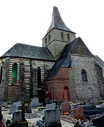 The church in Notre-Dame-d'Aliermont | |
Location of Notre-Dame-d'Aliermont | |
 Notre-Dame-d'Aliermont  Notre-Dame-d'Aliermont | |
| Coordinates: 49°51′11″N 1°17′30″E / 49.8531°N 1.2917°E | |
| Country | France |
| Region | Normandy |
| Department | Seine-Maritime |
| Arrondissement | Dieppe |
| Canton | Dieppe-2 |
| Intercommunality | CC Falaises du Talou |
| Government | |
| • Mayor (2020–2026) | Christophe Fromentin[1] |
| Area 1 | 13.31 km2 (5.14 sq mi) |
| Population | 733 |
| • Density | 55/km2 (140/sq mi) |
| Time zone | UTC+01:00 (CET) |
| • Summer (DST) | UTC+02:00 (CEST) |
| INSEE/Postal code | 76472 /76510 |
| Elevation | 94–196 m (308–643 ft) (avg. 160 m or 520 ft) |
| 1 French Land Register data, which excludes lakes, ponds, glaciers > 1 km2 (0.386 sq mi or 247 acres) and river estuaries. | |
Notre-Dame-d'Aliermont is a commune in the Seine-Maritime department in the Normandy region in northern France.
Geography
A farming village situated in the Pays de Caux at the junction of the D22 and the D56 roads, some 10 miles (16 km) southeast of Dieppe.
Population
| Year | Pop. | ±% p.a. |
|---|---|---|
| 1968 | 395 | — |
| 1975 | 441 | +1.59% |
| 1982 | 486 | +1.40% |
| 1990 | 525 | +0.97% |
| 1999 | 538 | +0.27% |
| 2007 | 621 | +1.81% |
| 2012 | 715 | +2.86% |
| 2017 | 771 | +1.52% |
| Source: INSEE[3] | ||
Places of interest
- The church of Notre-Dame, dating from the thirteenth century.
See also
References
- ↑ "Répertoire national des élus: les maires" (in French). data.gouv.fr, Plateforme ouverte des données publiques françaises. 13 September 2022.
- ↑ "Populations légales 2021". The National Institute of Statistics and Economic Studies. 28 December 2023.
- ↑ Population en historique depuis 1968, INSEE
Wikimedia Commons has media related to Notre-Dame-d'Aliermont.
This article is issued from Wikipedia. The text is licensed under Creative Commons - Attribution - Sharealike. Additional terms may apply for the media files.