Olliergues | |
|---|---|
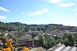 A general view of Olliergues | |
.svg.png.webp) Coat of arms | |
Location of Olliergues | |
 Olliergues  Olliergues | |
| Coordinates: 45°40′30″N 3°38′13″E / 45.675°N 3.637°E | |
| Country | France |
| Region | Auvergne-Rhône-Alpes |
| Department | Puy-de-Dôme |
| Arrondissement | Ambert |
| Canton | Les Monts du Livradois |
| Government | |
| • Mayor (2020–2026) | Arnaud Provenchere[1] |
| Area 1 | 16.41 km2 (6.34 sq mi) |
| Population | 743 |
| • Density | 45/km2 (120/sq mi) |
| Time zone | UTC+01:00 (CET) |
| • Summer (DST) | UTC+02:00 (CEST) |
| INSEE/Postal code | 63258 /63880 |
| Elevation | 382–663 m (1,253–2,175 ft) (avg. 432 m or 1,417 ft) |
| 1 French Land Register data, which excludes lakes, ponds, glaciers > 1 km2 (0.386 sq mi or 247 acres) and river estuaries. | |
Olliergues (French pronunciation: [ɔljɛʁɡ]; Occitan: Olhargues) is a commune in the Puy-de-Dôme department in Auvergne in central France.[3]
See also
References
- ↑ "Répertoire national des élus: les maires". data.gouv.fr, Plateforme ouverte des données publiques françaises (in French). 2 December 2020.
- ↑ "Populations légales 2021". The National Institute of Statistics and Economic Studies. 28 December 2023.
- ↑ INSEE commune file
Wikimedia Commons has media related to Olliergues.
This article is issued from Wikipedia. The text is licensed under Creative Commons - Attribution - Sharealike. Additional terms may apply for the media files.