Ourdis-Cotdoussan | |
|---|---|
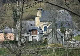 The hamlet of Cotdoussan and the church of Saint-Jacques | |
.svg.png.webp) Coat of arms | |
Location of Ourdis-Cotdoussan | |
 Ourdis-Cotdoussan  Ourdis-Cotdoussan | |
| Coordinates: 43°02′51″N 0°01′22″E / 43.0475°N 0.0228°E | |
| Country | France |
| Region | Occitania |
| Department | Hautes-Pyrénées |
| Arrondissement | Argelès-Gazost |
| Canton | Lourdes-2 |
| Intercommunality | CA Tarbes-Lourdes-Pyrénées |
| Area 1 | 4.85 km2 (1.87 sq mi) |
| Population | 44 |
| • Density | 9.1/km2 (23/sq mi) |
| Time zone | UTC+01:00 (CET) |
| • Summer (DST) | UTC+02:00 (CEST) |
| INSEE/Postal code | 65348 /65100 |
| Elevation | 594–1,499 m (1,949–4,918 ft) (avg. 610 m or 2,000 ft) |
| 1 French Land Register data, which excludes lakes, ponds, glaciers > 1 km2 (0.386 sq mi or 247 acres) and river estuaries. | |
Ourdis-Cotdoussan is a commune in the Hautes-Pyrénées department in south-western France.[2]
See also
References
- ↑ "Populations légales 2021". The National Institute of Statistics and Economic Studies. 28 December 2023.
- ↑ Commune d'Ourdis-Cotdoussan (65348), INSEE
Wikimedia Commons has media related to Ourdis-Cotdoussan.
This article is issued from Wikipedia. The text is licensed under Creative Commons - Attribution - Sharealike. Additional terms may apply for the media files.