Pardinho | |
|---|---|
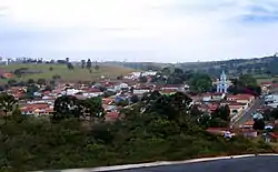 View of Pardinho | |
 Coat of arms | |
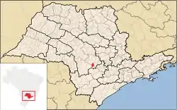 Location in São Paulo state | |
 Pardinho Location in Brazil | |
| Coordinates: 23°4′52″S 48°22′25″W / 23.08111°S 48.37361°W | |
| Country | Brazil |
| Region | Southeast |
| State | São Paulo |
| Area | |
| • Total | 210 km2 (80 sq mi) |
| Population (2020 [1]) | |
| • Total | 6,508 |
| • Density | 31/km2 (80/sq mi) |
| Time zone | UTC−3 (BRT) |
Pardinho is a municipality in the state of São Paulo in Brazil. The population is 6,508 (2020 est.) in an area of 210 km².[2] The elevation is 898 m. Pardinho became an independent municipality in 1959, when it was separated from Botucatu.[3]
References
This article is issued from Wikipedia. The text is licensed under Creative Commons - Attribution - Sharealike. Additional terms may apply for the media files.