22°25′44″S 43°25′08″W / 22.42889°S 43.41889°W
Paty do Alferes | |
|---|---|
.jpg.webp) | |
 Flag  Seal | |
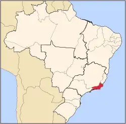
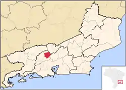 Location of Paty do Alferes in Rio de Janeiro State and Brazil | |
| Coordinates: 22°25′44″S 43°25′08″W / 22.42889°S 43.41889°W | |
| Country | Brazil |
| Region | Southeast |
| State | Rio de Janeiro |
| First settlers | 1710 |
| Freguesia | 1739 |
| Municipality | December 15, 1988 |
| Government | |
| • Prefeito (Mayor) | Lúcia de Fátima Fernandes Fonseca (until 2008) |
| Area | |
| • Total | 319.103 km2 (123.206 sq mi) |
| Elevation | 610 m (2,000 ft) |
| Population (2020 [1]) | |
| • Total | 27,858 |
| • Density | 78.8/km2 (204/sq mi) |
| Time zone | UTC−3 (BRT) |
| Website | www |
Paty do Alferes (Portuguese pronunciation: [paˈtʃi dwawˈfɛɾis]) is a municipality located in the Brazilian state of Rio de Janeiro.
References
Capital: Rio de Janeiro | |||||||||||
| Mesoregion Baixadas |
|  | |||||||||
| Mesoregion Centro Fluminense |
| ||||||||||
| Mesoregion Metropolitana do Rio de Janeiro |
| ||||||||||
| Mesoregion Noroeste Fluminense |
| ||||||||||
| Mesoregion Norte Fluminense |
| ||||||||||
| Mesoregion Sul Fluminense |
| ||||||||||
This article is issued from Wikipedia. The text is licensed under Creative Commons - Attribution - Sharealike. Additional terms may apply for the media files.