São José de Ubá | |
|---|---|
Municipality | |
| Município de São José de Ubá | |
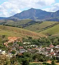 Skyline | |
 Flag  Seal | |
| Nickname: Tomatoland | |
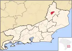 Location of São José de Ubá in the state of Rio de Janeiro | |
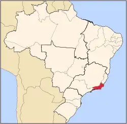
 São José de Ubá Location of São José de Ubá in Brazil | |
| Coordinates: 21°21′28″S 41°56′34″W / 21.35778°S 41.94278°W | |
| Country | |
| Region | Southeast |
| State | |
| Government | |
| • Prefeito | Marcionílio Botelho Moreira (PP) |
| Area | |
| • Total | 250.596 km2 (96.756 sq mi) |
| Elevation | 95 m (312 ft) |
| Population (2020 [1]) | |
| • Total | 7,206 |
| Time zone | UTC−3 (BRT) |
| Website | |
São José de Ubá (Portuguese pronunciation: [ˈsɐ̃w ʒuˈzɛ dʒ(j)uˈba]) is a municipality located in the Brazilian state of Rio de Janeiro. Its population was 7,206 (2020) and its area is 251 km².[2]
References
Capital: Rio de Janeiro | |||||||||||
| Mesoregion Baixadas |
|  | |||||||||
| Mesoregion Centro Fluminense |
| ||||||||||
| Mesoregion Metropolitana do Rio de Janeiro |
| ||||||||||
| Mesoregion Noroeste Fluminense |
| ||||||||||
| Mesoregion Norte Fluminense |
| ||||||||||
| Mesoregion Sul Fluminense |
| ||||||||||
This article is issued from Wikipedia. The text is licensed under Creative Commons - Attribution - Sharealike. Additional terms may apply for the media files.