Plouguiel
Priel | |
|---|---|
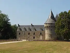 The château of Kéralio | |
Location of Plouguiel | |
 Plouguiel  Plouguiel | |
| Coordinates: 48°47′53″N 3°14′22″W / 48.7981°N 3.2394°W | |
| Country | France |
| Region | Brittany |
| Department | Côtes-d'Armor |
| Arrondissement | Lannion |
| Canton | Tréguier |
| Intercommunality | Lannion-Trégor Communauté |
| Government | |
| • Mayor (2020–2026) | Pierre Huonnic[1] |
| Area 1 | 19.07 km2 (7.36 sq mi) |
| Population | 1,745 |
| • Density | 92/km2 (240/sq mi) |
| Time zone | UTC+01:00 (CET) |
| • Summer (DST) | UTC+02:00 (CEST) |
| INSEE/Postal code | 22221 /22220 |
| Elevation | 0–76 m (0–249 ft) |
| 1 French Land Register data, which excludes lakes, ponds, glaciers > 1 km2 (0.386 sq mi or 247 acres) and river estuaries. | |
Plouguiel (French pronunciation: [pluɡjɛl] ⓘ; Breton: Priel) is a commune in the Côtes-d'Armor department of Brittany in northwestern France.
Population
| Year | Pop. | ±% |
|---|---|---|
| 1962 | 1,928 | — |
| 1968 | 2,017 | +4.6% |
| 1975 | 2,058 | +2.0% |
| 1982 | 2,022 | −1.7% |
| 1990 | 2,056 | +1.7% |
| 1999 | 1,858 | −9.6% |
| 2008 | 1,899 | +2.2% |
Inhabitants of Plouguiel are called plouguielois in French.
See also
References
- ↑ "Répertoire national des élus: les maires" (in French). data.gouv.fr, Plateforme ouverte des données publiques françaises. 13 September 2022.
- ↑ "Populations légales 2021". The National Institute of Statistics and Economic Studies. 28 December 2023.
External links
Wikimedia Commons has media related to Plouguiel.
- Official website (in French)
- Base Mérimée: Search for heritage in the commune, Ministère français de la Culture. (in French)
This article is issued from Wikipedia. The text is licensed under Creative Commons - Attribution - Sharealike. Additional terms may apply for the media files.