Route 131 | ||||
|---|---|---|---|---|
 | ||||
| Route information | ||||
| Maintained by Transports Québec | ||||
| Length | 125.2 km[1] (77.8 mi) | |||
| History | ||||
| Major junctions | ||||
| South end | ||||
| North end | Chemin de Saint-Ignace in Saint-Michel-des-Saints | |||
| Location | ||||
| Country | Canada | |||
| Province | Quebec | |||
| Highway system | ||||
| ||||

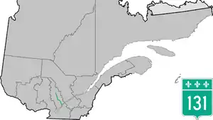
Route 131 is a Quebec highway running from Lavaltrie (junction of Route 138) to Saint-Michel-des-Saints in Lanaudière. This route, combined with Autoroute 31, provides the key route to Joliette, and then continues northward through Saint-Félix-de-Valois, Saint-Jean-de-Matha and Saint-Zénon for a distance of approximately 125 kilometres (78 mi).
Municipalities along Route 131
Major intersections
| RCM | Location | km[1] | mi | Destinations | Notes | ||
|---|---|---|---|---|---|---|---|
| D'Autray | Lavaltrie | 0.0 | 0.0 | R-131 southern terminus | |||
| 2.4 | 1.5 | A-31 southern terminus; south end of A-31 concurrency; A-31 exit 1; A-40 exit 122 | |||||
| See Quebec Autoroute 31 § Exit list | |||||||
| Joliette | Joliette | 19.1 | 11.9 | A-31 northern terminus; north end of A-31 concurrency; A-31 exit 14; south end of R-158 concurrency | |||
| 19.9 | 12.4 | North end of R-158 concurrency | |||||
| 22.1 | 13.7 | Boulevard Firestone | |||||
| Notre-Dame-des-Prairies | 23.2 | 14.4 | Boulevard Antonio-Barrette | ||||
| Matawinie | Saint-Félix-de-Valois | 36.7 | 22.8 | ||||
| 39.8 | 24.7 | South end of R-348 concurrency | |||||
| 40.7 | 25.3 | North end of R-348 concurrency | |||||
| Saint-Jean-de-Matha | 48.3 | 30.0 | |||||
| Sainte-Émélie-de-l'Énergie | 57.7 | 35.9 | South end of R-347 concurrency | ||||
| 64.9 | 40.3 | North end of R-347 concurrency | |||||
| Saint-Michel-des-Saints | 125.2 | 77.8 | Chemin Saint-Ignace | R-131 northern terminus | |||
1.000 mi = 1.609 km; 1.000 km = 0.621 mi
| |||||||
In other media
The route is name-dropped in the opening lyrics of the song "Le Shack à Hector" by Repentigny-based neo-trad band Les Cowboys Fringants.[2]
See also
References
- 1 2 Google (April 16, 2023). "Quebec Route 131" (Map). Google Maps. Google. Retrieved April 16, 2023.
- ↑ Le shack à Hector (Les Cowboys fringants) - Partitions - La Boîte à chansons ♫ (in French), retrieved 2023-08-28
External links
- Provincial Route Map (Courtesy of the Quebec Ministry of Transportation) (in French)
- Route 131 on Google Maps
46°01′45″N 73°24′28″W / 46.0292°N 73.4079°W
This article is issued from Wikipedia. The text is licensed under Creative Commons - Attribution - Sharealike. Additional terms may apply for the media files.