.jpg.webp)
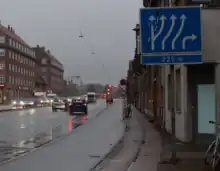
Road signs in Copenhagen.
This is a list of road signs in Denmark.
Denmark signed the Vienna Convention on Road Signs and Signals on November 8, 1968 and ratified it on November 3, 1986.[1]
A: Warning signs
- Warning signs
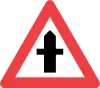 A11: Dangerous crossroad with a non-priority road
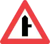 A12.1: Dangerous side road with a non-priority road
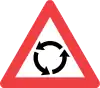 A16: Roundabout
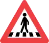 A17: Pedestrian crossing
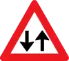 A18: Two-way traffic
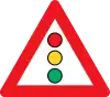 A19: Traffic signals
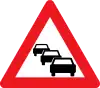 A20: Traffic queue
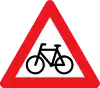 A21: Cyclists
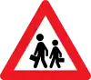 A22: Children
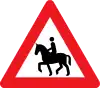 A23: Equestrians
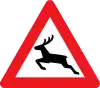 A26: Wild animals
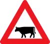 A27: Cattle
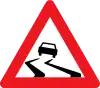 A31: Slippery road
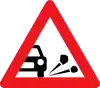 A33: Loose chippings
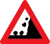 A34: Rockfall
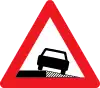 A35: Dangerous shoulder
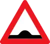 A36: Bump
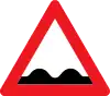 A37: Uneven road
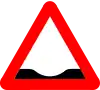 A38: Dip [2]
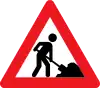 A39: Roadworks
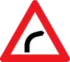 A41.1: Curve to the right
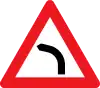 A41.2: Curve to the left
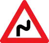 A42.1: Multiple curves, first to the right
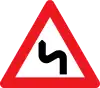 A42.2: Multiple curves, first to the left
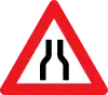 A43.1: Road narrows
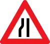 A43.2: Road narrows to the left
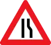 A43.3: Road narrows to the right
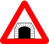 A44: Tunnel
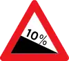 A46.1 Downward gradient
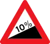 A46.2: Upward gradient
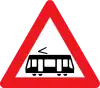 A71: Light rail
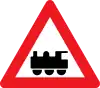 A72: Level crossing without gates
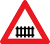 A73: Level crossing with gates
 A74.1: Single track level crossing
 A74.2: Multi track level crossing
 A75: Distance to level crossing
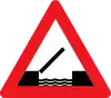 A91: Opening bridge
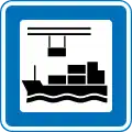
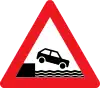 A92: Quayside
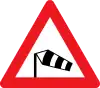 A95: Side winds
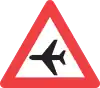 A96: Low airplanes
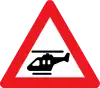 A97: Low helicopters
 A99: Other danger
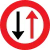
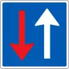
B: Priority signs


C: Prohibitory signs
- Prohibitory signs
 C11.1: No right turn
 C11.2: No left turn
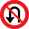 C12: No U-turns
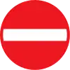 C19: No entry
 C21: Driving in both directions prohibited
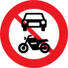 C22.1: No motor vehicles
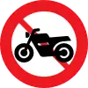 C22.2: No motorcycles or large mopeds
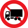 C23.1: No lorries
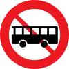 C23.2: No buses
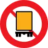 C23.3: No vehicles carrying dangerous goods
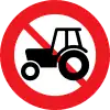 C24.1: No tractors or motor equipment
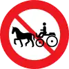 C24.2: No horse-drawn vehicles or similar
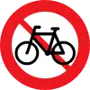 C25.1: No bicycles or small mopeds[3]
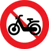 C25.2: No small mopeds
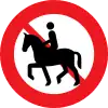 C26.1: No equestrians
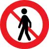 C26.2: No pedestrians
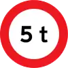 C31: Max weight
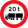 C32: Max weight of roadtrain
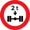 C35: Max axle load
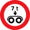 C36: Max bogie load
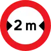 C41: Max width
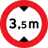 C42: Max height
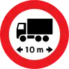 C43: Max length
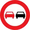 C51: No overtaking
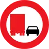 C52: No overtaking by truck
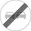 C53: End of no overtaking
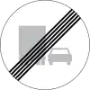 C54: End of no overtaking by truck
 C55: Local speed limit
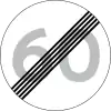 C56: End of local speed limit
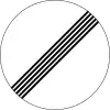 C59: End of prohibition
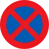 C61: No stopping
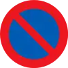 C62: No parking
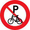 C63: No parking for bicycles
 C92: Continuing without stop prohibited
D: Mandatory signs
- Mandatory signs
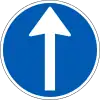 D11.1: Mandatory direction
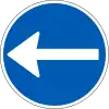 D11.2: Mandatory direction
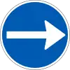 D11.3: Mandatory direction
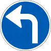 D11.4: Mandatory direction
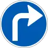 D11.5: Mandatory direction
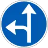 D11.6: Mandatory direction
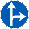 D11.7: Mandatory direction
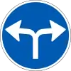 D11.8: Mandatory direction
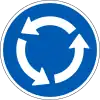 D12: Mandatory direction in the roundabout
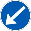 D15.2: Mandatory passage
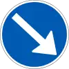 D15.3: Mandatory passage
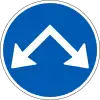 D16: Passage
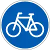 D21: Cycleway
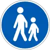 D22: Footway
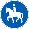 D23: Bridleway
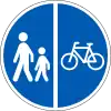 D26: Segregated path
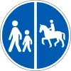 D26.1: Segregated path
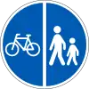 D26.2: Segregated path
 D26.3: Segregated path
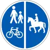 D26.4: Segregated path
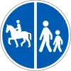 D26.5: Segregated path
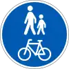 D27: Combined path
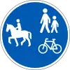 D27.1: Combined path
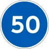 D55: Minimum speed
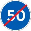 D56: End of minimum speed
E: Information signs
Arrow signs (E11) are suspended above the carriageway
- Arrow signs suspended above lanes at intersection
 E11.1: Continue straight
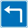 E11.4: Turn left
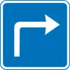 E11.5: Turn right
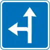 E11.6: Continue straight or turn left
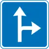 E11.7: Continue straight or turn right
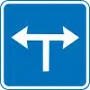 E11.8: Turn left or right
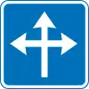 E11.9: Continue straight, turn left or right
Direction of lanes at intersection(E15)
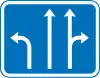 E15: Lanes at intersection
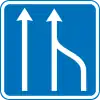 E16.1: Reduction of number of lanes
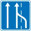 E16.2: Reduction of number of lanes
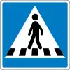 E17: Pedestrian crossing
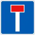 E18: Dead end
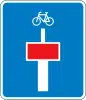 E18.1.1: Dead end with continuing cyclepath
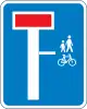 E18.1.2: Dead end with continuing cyclepath to the right
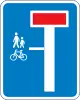 E18.1.3: Dead end with continuing cyclepath to the left
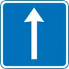
 E19: One way
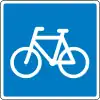 E21.1: Recommended route for cyclists
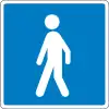 E21.2: Recommended route for pedestrians
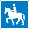 E21.3: Recommended route for equestrians
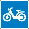 E21.4: Recommended route for mopeds
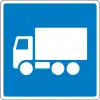 E22.1: Recommended route for lorries
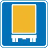 E22.2: Recommended route for hazardous goods vehicles
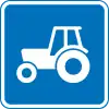 E22.3: Recommended route for tractors and motor equipment
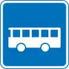 E22.4: Recommended route for busses
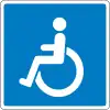 E23: Instructions for disabled
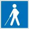 E24: Instructions for visually impaired
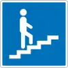 E26.1: Pedestrian overpass
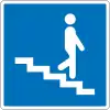 E26.2: Pedestrian underpass
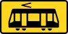 E30: Light rail stop
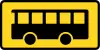 E31: Bus stop
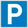 E33.1: Parking
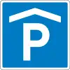 E33.2: Indoor parking
 UE33.4: Charging, subpanel to E33
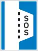 E34: Breakdown bay
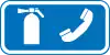 UE34: Fire extinguisher and emergency phone, subpanel to E34
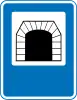 E35: Tunnel
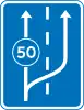 E37: Slow lane begins
 E39: Advisory maxspeed
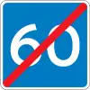 E40: End of advisory maxspeed
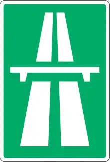 E42: Motorway
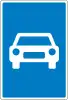 E43: Trunk road
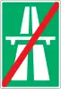 E44: End of Motorway
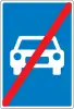 E45: End of Trunk road
 E47: Bicycle boulevard
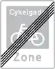 E48: End of Bicycle boulevard
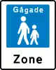 E49: Pedestrian zone
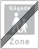 E50: End of Pedestrian zone
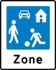 E51: Living street
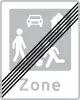 E52: End of living street
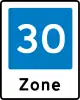 E53: Zone with traffic calming
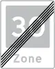 E53: End of zone with traffic calming
 E55: Urban area
 E56: End of urban area
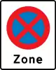 E68.2: Zone with no stopping
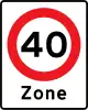 E68.4: Zone with local speed limit
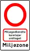 E68.9: Low-emission zone
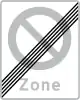 E69: End of zone with no parking
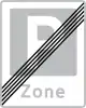 E69.3: End of zone with parking
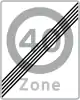 E69.4: End of zone with local speed limit
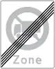 E69.5: End of zone with no lorries
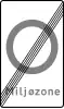 E69.9: End of low-emission zone
 E80: General speed limits
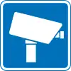 E93: Video surveillance
F: Direction signs
- Direction signs
 F11: Arrow direction sign
 F12: Arrow direction sign
 F13: Arrow direction sign
 F14: Temporary arrow direction sign
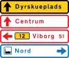 F18: Tabular direction signs
 F30: Service road direction sign
 F33.2: Tabular direction signs for parking
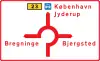
G: Orientation signs
- Orientation signs
 G14: Diagram orientation
 G15: Lane orientation
 G18: Tabular orientation
M: Service signs
New service signs can be designed when needed, eg. by request from a business. The permission to do this is found in §359 ¶2 of Regulation of the Use of Road Signs and Markings.[4] A list of approved signs can be found on the Danish Road Directorate's (Vejdirektoratet) webpage. Signs planned, but not designed yet, are "electrician" and "real estate agent".[5]
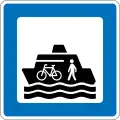 M10: Ferry for pedestrians and bicycles
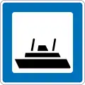 M11: Car ferry
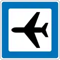 M12: Airport
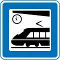 M13: Train station
(formerly used )
)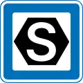 M13.1: S-train station
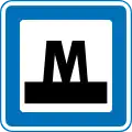 M13.2 Metro station
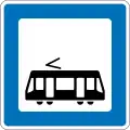 M13.3: Light rail station
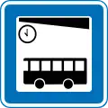 M14: Bus station
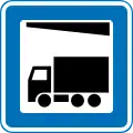 M15: Freight terminal
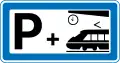 M16: Park and ride
(formerly used )
)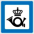 M17: Post Office
 M18: Hub (communal transport)
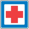 M21: Emergency department, open 24 hours a day
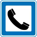 M22: Telephone
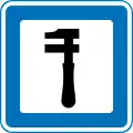 M23: Breakdown service
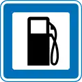 M24: Filling station
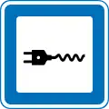 M24.1: Charging station for EV
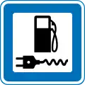 M24.2: Charging and filling station
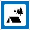 M30: Primitive camp site for hikers
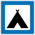 M31: Camping and caravan site
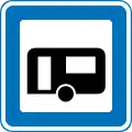 M31.1: Site exclusivly for caravans
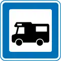 M32: Autocamper site
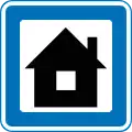 M33: Camping cabins
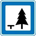 M34: Rest area
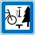 M34.1: Rest area for cyclists
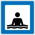 M35: Beach or swimming pool
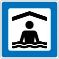 M35.1: Indoor swimming pool
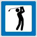 M36: Golf Course
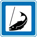 M37: Put and take fishing
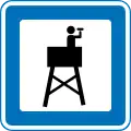 M38: Observation tower
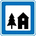 M41: Youth hostel
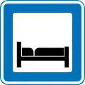 M42: Hotel
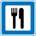 M43: Restaurant
 M45: Cafeteria
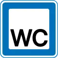 M46: Toilet
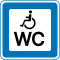 M46.1: Toilet (handicapped)
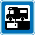 M47: Emptying chemical toilet
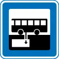 M47.1: Emptying chemical toilet
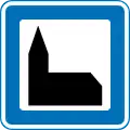 M51: Church
 M52.1: Local attraction
 M52.2: National attraction
 M53: Unesco world heritage site
 M54: National Park
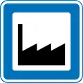 M57: Industrial area
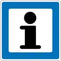 M61: Information point
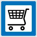 M101: Grocery store
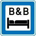 M102: Room to let
 M103: Baker
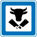 M104: Butcher
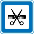 M105: Hairdresser
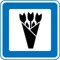 M107: Florist
 M109: Bookshop
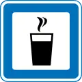 M111: Café
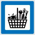 M112: Farm shop
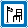 M113: Antiques
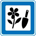 M114: Garden centre, plant nursery etc.
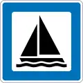 M115: Marina
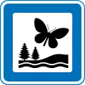 M116: Nature reserve
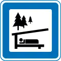 M117: Trail shelter
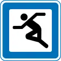 M118: Sports facility
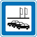 M119: Car dealership, car rental
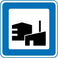 M120: Commercial district
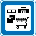 M121: Shopping center, street, etc.
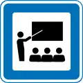 M123: Education
 M124: Veterinary clinic or hospital
 M125: Kindergarten etc.
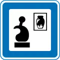 M126: Art, pottery, etc.
 M127: Miltary
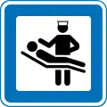 M128: Hospital
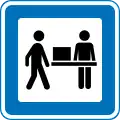 M129: Public offices
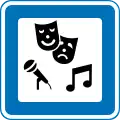 M130: Cultural center
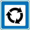 M131: Recycling
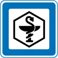 M132: Pharmacy
 M133: Cinema
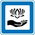 M134: Wellness, massage, beauty clinic, etc.
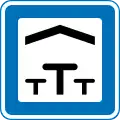 M138: Picnic area, indoor or outdoor
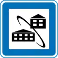 M140: Cohousing
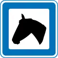 M143: Stud farm
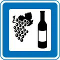 M144: Winery
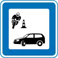 M145: Drivers education
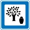 M146: Forest burial ground (cremated remains)
Historic signs
.svg.png.webp) A21: Cyclists
A21: Cyclists.svg.png.webp) A22: Children
A22: Children.svg.png.webp) A99: Other danger
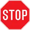
A99: Other danger.svg.png.webp) B13: Stop
B13: Stop.svg.png.webp) C12: No U-turn
C12: No U-turn.svg.png.webp) C51: No overtaking
C51: No overtaking.svg.png.webp) D21: Cycleway
D21: Cycleway.svg.png.webp) D22: Footway
D22: Footway.svg.png.webp) D27: Combined path
D27: Combined path.svg.png.webp) E17: Pedestrian crossing
E17: Pedestrian crossing.svg.png.webp) E33.1: Parking
E33.1: Parking
References
- ↑ "United Nations Treaty Collection". treaties.un.org. Retrieved 2023-12-07.
- ↑ Transportministeriet (2023), Bekendtgørelse om vejafmærkning, retrieved 11 July 2023
- ↑ In danish regulation, the symbol for bicycle also applies to a class of vehicles called small mopeds (50cc and restricted to max 30 km/h). Cf. "US 8: Cykel og lille knallert" in: "BEK nr 425 af 13/04/2023, Transportministeriet". Retsinformation (in Danish). Retrieved 2023-11-28. https://www.retsinformation.dk/eli/lta/2023/425
- ↑ "BEK nr 426 af 13/04/2023, Transportministeriet". Retsinformation (in Danish). Retrieved 2023-12-14.
- ↑ "Liste med samtlige godkendte servicetavler med symboler til kommerciel servicevejvisning".
External links
 Media related to Diagrams of road signs of Denmark at Wikimedia Commons
This article is issued from Wikipedia. The text is licensed under Creative Commons - Attribution - Sharealike. Additional terms may apply for the media files.