Rokiškis District Municipality
Rokiškio rajono savivaldybė | |
|---|---|
 Coat of arms | |
 Location of Rokiškis district municipality within Lithuania | |
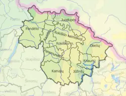 Map of Rokiškis district municipality | |
| Country | |
| Ethnographic region | Aukštaitija |
| County | |
| Capital | Rokiškis |
| Elderships | 10 |
| Area | |
| • Total | 1,807 km2 (698 sq mi) |
| • Rank | 4-5th |
| Population (2021[1]) | |
| • Total | 28,715 |
| • Rank | 26th |
| • Density | 16/km2 (41/sq mi) |
| • Rank | 46th |
| Time zone | UTC+2 (EET) |
| • Summer (DST) | UTC+3 (EEST) |
| Telephone code | 458 |
| Major settlements | |
| Website | www |
Rokiškis District Municipality is one of 60 municipalities in Lithuania.
Structure
District structure:
- 3 cities – Obeliai, Pandėlys and Rokiškis;
- 9 towns – Čedasai, Duokiškis, Juodupė, Jūžintai, Kamajai, Panemunėlis, Panemunis, Salos and Suvainiškis;
- 689 villages.
Population of largest elderships in Rokiškis District Municipality (2001):
References

This article is issued from Wikipedia. The text is licensed under Creative Commons - Attribution - Sharealike. Additional terms may apply for the media files.