Ságvár
Tricciana (in Latin) | |
|---|---|
Village | |
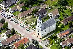 Centre of Ságvár | |
 Coat of arms | |
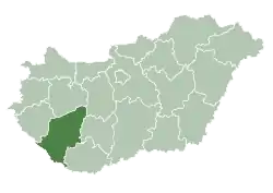
 Ságvár Location of Ságvár | |
| Coordinates: 46°50′13″N 18°06′07″E / 46.83707°N 18.10202°E | |
| Country | |
| Region | Southern Transdanubia |
| County | Somogy |
| District | Siófok |
| RC Diocese | Kaposvár |
| Area | |
| • Total | 38.44 km2 (14.84 sq mi) |
| Population (2017) | |
| • Total | 1,787[1] |
| Demonym | ságvári |
| Time zone | UTC+1 (CET) |
| • Summer (DST) | UTC+2 (CEST) |
| Postal code | 8654 |
| Area code | (+36) 84 |
| NUTS 3 code | HU232 |
| MP | Mihály Witzmann (Fidesz) |
| Website | Ságvár Online |
Ságvár (Latin: Tricciana) is a village in Somogy county, Hungary.
Etymology
According to the local legends the settlement was named after a pasha called Ság who had a castle there. Researchers agree that Ság was a Kabar or Hungarian person name which could be the name of its first owner. The word ság meant in old Hungarian domb (English: hill) or erdős magaslat (English: wooded heights). Vár (English: castle) refers to the traces of a Roman castle in Ságvár.[2]
History
According to László Szita the settlement was completely Hungarian in the 18th century.[3]
External links
References
| Towns (3) |
| |
|---|---|---|
| Large village (1) | ||
| Villages (20) | ||
This article is issued from Wikipedia. The text is licensed under Creative Commons - Attribution - Sharealike. Additional terms may apply for the media files.