Sankt Radegund bei Graz | |
|---|---|
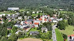 Southeast view of St. Radegund bei Graz | |
 Coat of arms | |
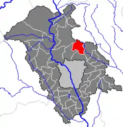 Location within Graz-Umgebung district | |
 Sankt Radegund bei Graz Location within Austria | |
| Coordinates: 47°10′52″N 15°29′22″E / 47.18111°N 15.48944°E | |
| Country | Austria |
| State | Styria |
| District | Graz-Umgebung |
| Government | |
| • Mayor | Hannes Kogler (ÖVP) |
| Area | |
| • Total | 21.60 km2 (8.34 sq mi) |
| Elevation | 717 m (2,352 ft) |
| Population (2018-01-01)[2] | |
| • Total | 2,165 |
| • Density | 100/km2 (260/sq mi) |
| Time zone | UTC+1 (CET) |
| • Summer (DST) | UTC+2 (CEST) |
| Postal code | 8061 |
| Area code | 03132 |
| Vehicle registration | GU |
| Website | www.radegund.info |
Sankt Radegund bei Graz is a municipality in the district of Graz-Umgebung in the Austrian state of Styria. It is named after Saint Radegund.
Population
| Year | Pop. | ±% |
|---|---|---|
| 1869 | 953 | — |
| 1880 | 976 | +2.4% |
| 1890 | 1,093 | +12.0% |
| 1900 | 1,061 | −2.9% |
| 1910 | 1,111 | +4.7% |
| 1923 | 1,025 | −7.7% |
| 1934 | 1,134 | +10.6% |
| 1939 | 1,129 | −0.4% |
| 1951 | 1,312 | +16.2% |
| 1961 | 1,358 | +3.5% |
| 1971 | 1,524 | +12.2% |
| 1981 | 1,709 | +12.1% |
| 1991 | 1,071 | −37.3% |
| 2001 | 2,001 | +86.8% |
References
- ↑ "Dauersiedlungsraum der Gemeinden Politischen Bezirke und Bundesländer - Gebietsstand 1.1.2018". Statistics Austria. Retrieved 10 March 2019.
- ↑ "Einwohnerzahl 1.1.2018 nach Gemeinden mit Status, Gebietsstand 1.1.2018". Statistics Austria. Retrieved 9 March 2019.
This article is issued from Wikipedia. The text is licensed under Creative Commons - Attribution - Sharealike. Additional terms may apply for the media files.