Schnepfau | |
|---|---|
 | |
 Coat of arms | |
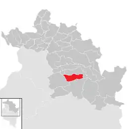 Location in the district | |
 Schnepfau Location within Austria | |
| Coordinates: 47°21′00″N 09°56′00″E / 47.35000°N 9.93333°E | |
| Country | Austria |
| State | Vorarlberg |
| District | Bregenz |
| Government | |
| • Mayor | Josef Moosbrugger |
| Area | |
| • Total | 16.53 km2 (6.38 sq mi) |
| Elevation | 734 m (2,408 ft) |
| Population (2018-01-01)[2] | |
| • Total | 449 |
| • Density | 27/km2 (70/sq mi) |
| Time zone | UTC+1 (CET) |
| • Summer (DST) | UTC+2 (CEST) |
| Postal code | 6882 |
| Area code | 05518 |
| Vehicle registration | B |
| Website | www.schnepfau.at |
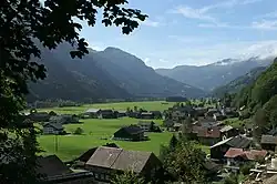
Schnepfau is a municipality in the district of Bregenz in the Austrian state of Vorarlberg.
Population
| Year | Pop. | ±% |
|---|---|---|
| 1869 | 409 | — |
| 1880 | 360 | −12.0% |
| 1890 | 346 | −3.9% |
| 1900 | 291 | −15.9% |
| 1910 | 302 | +3.8% |
| 1923 | 315 | +4.3% |
| 1934 | 339 | +7.6% |
| 1939 | 329 | −2.9% |
| 1951 | 406 | +23.4% |
| 1961 | 378 | −6.9% |
| 1971 | 339 | −10.3% |
| 1981 | 373 | +10.0% |
| 1991 | 432 | +15.8% |
| 2001 | 483 | +11.8% |
| 2011 | 473 | −2.1% |
References
- ↑ "Dauersiedlungsraum der Gemeinden Politischen Bezirke und Bundesländer - Gebietsstand 1.1.2018". Statistics Austria. Retrieved 10 March 2019.
- ↑ "Einwohnerzahl 1.1.2018 nach Gemeinden mit Status, Gebietsstand 1.1.2018". Statistics Austria. Retrieved 9 March 2019.
Wikimedia Commons has media related to Schnepfau.
This article is issued from Wikipedia. The text is licensed under Creative Commons - Attribution - Sharealike. Additional terms may apply for the media files.