Warth | |
|---|---|
 | |
 Coat of arms | |
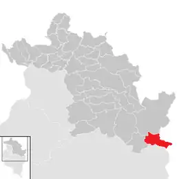 Location in the district | |
 Warth Location within Austria | |
| Coordinates: 47°15′0″N 10°10′0″E / 47.25000°N 10.16667°E | |
| Country | Austria |
| State | Vorarlberg |
| District | Bregenz |
| Government | |
| • Mayor | Stefan Strolz |
| Area | |
| • Total | 19.34 km2 (7.47 sq mi) |
| Elevation | 1,495 m (4,905 ft) |
| Population (2018-01-01)[2] | |
| • Total | 170 |
| • Density | 8.8/km2 (23/sq mi) |
| Time zone | UTC+1 (CET) |
| • Summer (DST) | UTC+2 (CEST) |
| Postal code | 6767 |
| Area code | 05583 |
| Vehicle registration | B |
| Website | www.warth-schroecken.com |
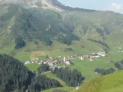
Warth is a municipality in the district of Bregenz in the Austrian state of Vorarlberg.
Population
| Year | Pop. | ±% |
|---|---|---|
| 1869 | 143 | — |
| 1880 | 117 | −18.2% |
| 1890 | 124 | +6.0% |
| 1900 | 104 | −16.1% |
| 1910 | 109 | +4.8% |
| 1923 | 93 | −14.7% |
| 1934 | 130 | +39.8% |
| 1939 | 111 | −14.6% |
| 1951 | 129 | +16.2% |
| 1961 | 120 | −7.0% |
| 1971 | 161 | +34.2% |
| 1981 | 154 | −4.3% |
| 1991 | 187 | +21.4% |
| 2001 | 203 | +8.6% |
| 2011 | 186 | −8.4% |
References
- ↑ "Dauersiedlungsraum der Gemeinden Politischen Bezirke und Bundesländer - Gebietsstand 1.1.2018". Statistics Austria. Retrieved 10 March 2019.
- ↑ "Einwohnerzahl 1.1.2018 nach Gemeinden mit Status, Gebietsstand 1.1.2018". Statistics Austria. Retrieved 9 March 2019.
Wikimedia Commons has media related to Warth (Vorarlberg).
This article is issued from Wikipedia. The text is licensed under Creative Commons - Attribution - Sharealike. Additional terms may apply for the media files.