Spodnja Bačkova | |
|---|---|
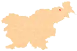
 Spodnja Bačkova Location in Slovenia | |
| Coordinates: 46°38′14.83″N 15°52′56.38″E / 46.6374528°N 15.8823278°E | |
| Country | |
| Traditional region | Styria |
| Statistical region | Drava |
| Municipality | Benedikt |
| Area | |
| • Total | 2.45 km2 (0.95 sq mi) |
| Elevation | 304.5 m (999.0 ft) |
| Population (2020) | |
| • Total | 132 |
| • Density | 54/km2 (140/sq mi) |
| [1] | |
Spodnja Bačkova (pronounced [ˈspoːdnja ˈbaːtʃkɔʋa]) is a settlement in the Slovene Hills (Slovene: Slovenske gorice) in the Municipality of Benedikt in northeastern Slovenia. The area is part of the traditional region of Styria. It is now included in the Drava Statistical Region.[2]
A small hexagonal chapel-shrine in the settlement dates to 1871.[3]
References
External links
This article is issued from Wikipedia. The text is licensed under Creative Commons - Attribution - Sharealike. Additional terms may apply for the media files.