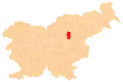
Spodnje Grušovlje | |
|---|---|
 Spodnje Grušovlje Location in Slovenia | |
| Coordinates: 46°15′56.6″N 15°6′57.07″E / 46.265722°N 15.1158528°E | |
| Country | |
| Traditional region | Styria |
| Statistical region | Savinja |
| Municipality | Žalec |
| Area | |
| • Total | 1.64 km2 (0.63 sq mi) |
| Elevation | 275.5 m (903.9 ft) |
| Population (2023)[1] | |
| • Total | 114 |
| [2] | |
Spodnje Grušovlje (pronounced [ˈspoːdnjɛ ɡɾuˈʃoːu̯ljɛ]) is a small settlement in the Municipality of Žalec in east-central Slovenia. It lies in the lower Savinja Valley north of Šempeter v Savinjski Dolini. The area is part of the traditional region of Styria. The municipality is now included in the Savinja Statistical Region.[3]
References
- ↑ "Naselje Spodnje Grušovlje". Krajevna imena. Statistični urad Republike Slovenije. Retrieved August 18, 2023.
- ↑ Statistical Office of the Republic of Slovenia
- ↑ Žalec municipal site
External links
This article is issued from Wikipedia. The text is licensed under Creative Commons - Attribution - Sharealike. Additional terms may apply for the media files.
