Táliga | |
|---|---|
 | |
.svg.png.webp) Flag  Coat of arms | |
 Táliga Location in Spain/Portugal  Táliga Táliga (Spain) | |
| Coordinates: 38°31′N 7°0′W / 38.517°N 7.000°W | |
| Country | |
| Spanish community | Extremadura |
| Spanish Province | Badajoz |
| Government | |
| • Alcalde | Inmaculada Bonilla Martínez (2007) (PSOE) |
| Area | |
| • Total | 31 km2 (12 sq mi) |
| Elevation | 315 m (1,033 ft) |
| Population (2018)[1] | |
| • Total | 681 |
| • Density | 22/km2 (57/sq mi) |
| Demonym | Taligueño/ña |
| Time zone | UTC+1 (CET) |
| • Summer (DST) | UTC+2 (CEST) |
| Postal code | 06133 |
| Official language(s) | Spanish |
| Website | Official website |
Táliga (Spanish: [ˈtaliɣa]) or Talega (Portuguese: [tɐˈlɛɣɐ]) is a Spanish town and municipality located near the border with Portugal, in the province of Badajoz, in the Spanish autonomous community of Extremadura. Portugal considers Táliga, as well as neighbouring Olivenza, a de jure part of the Portuguese concelho of Olivenza, occupied by Spain since 1801. (See Olivenza#Claims of sovereignty).
Under Portuguese administration, Táliga was a freguesia (parish) of the concelho (municipality) of Olivenza. It became an independent municipality in 1850, already under Spanish administration.
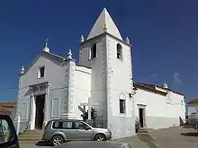
Church in Táliga
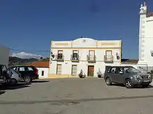
House in Táliga
References
- ↑ Municipal Register of Spain 2018. National Statistics Institute.
External links
Wikimedia Commons has media related to Táliga.
This article is issued from Wikipedia. The text is licensed under Creative Commons - Attribution - Sharealike. Additional terms may apply for the media files.