Trimountain, Michigan | |
|---|---|
 Trimountain  Trimountain | |
| Coordinates: 47°3′19″N 88°39′32″W / 47.05528°N 88.65889°W | |
| Country | United States |
| State | Michigan |
| County | Houghton |
| Township | Adams |
| Area | |
| • Total | 0.47 sq mi (1.21 km2) |
| • Land | 0.47 sq mi (1.21 km2) |
| • Water | 0.00 sq mi (0.00 km2) |
| Elevation | 1,305 ft (398 m) |
| Population (2020) | |
| • Total | 212 |
| • Density | 453.96/sq mi (175.09/km2) |
| Time zone | UTC-5 (Eastern (EST)) |
| • Summer (DST) | UTC-4 (EDT) |
| ZIP Codes | |
| Area code | 906 |
| FIPS code | 26-80480 |
| GNIS feature ID | 2806337[2] |
Trimountain is an unincorporated community and census-designated place (CDP) in the northern part of Adams Township, Houghton County, Michigan, United States. It is along highway M-26 between South Range to the northeast and Painesdale to the southwest. Houghton, the county seat, is 7 miles (11 km) to the northeast.
Trimountain was first listed as a CDP prior to the 2020 census.[2]
Demographics
| Census | Pop. | Note | %± |
|---|---|---|---|
| 2020 | 212 | — | |
| U.S. Decennial Census[3] | |||
References
- ↑ "2020 U.S. Gazetteer Files". United States Census Bureau. Retrieved May 21, 2022.
- 1 2 3 "Trimountain Census Designated Place". Geographic Names Information System. United States Geological Survey, United States Department of the Interior.
- ↑ "Census of Population and Housing". Census.gov. Retrieved June 4, 2016.
Municipalities and communities of Houghton County, Michigan, United States | ||
|---|---|---|
| Cities | 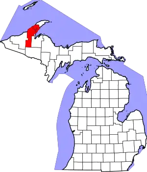 Map of Michigan highlighting Houghton County.svg | |
| Villages | ||
| Charter townships | ||
| Civil townships | ||
| CDPs | ||
| Other communities | ||
This article is issued from Wikipedia. The text is licensed under Creative Commons - Attribution - Sharealike. Additional terms may apply for the media files.