Tuek Chhou
ស្រុកទឹកឈូ | |
|---|---|
 | |
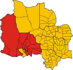 District location in Kampot province | |
| Coordinates: 10°36′N 104°10′E / 10.600°N 104.167°E | |
| Country | |
| Province | Kampot |
| Communes | 19 |
| Villages | 67 |
| Population (1998)[1] | |
| • Total | 89,779 |
| Time zone | +7 |
| Geocode | 0707 |
Tuek Chhou (Khmer: ស្រុកទឹកឈូ) is a district located in Kampot province, in southern Cambodia. It surrounds Krong Kampot, which contains the urban area of Kampot City.[2]
Administration
| Khum (communes) | Phum (villages) | Geocode |
|---|---|---|
| Boeng Tuk | Roluos, Kaeb Thmei, Totueng Thngai | 070701 |
| Chum Kriel | Trapeang Thum, Chum Kriel, Samraong, Kampong Kandal | 070702 |
| Kampong Kraeng | Makprang, Andoung Chi Meun, Prey Tnaot, Kampong Kraeng, kampongkrong | 070703 |
| Kampong Samraong | Trapeang Kanhchhaet, Kampong Samraong Khang Cheung, Kampong Samraong Khang Tboung | 070704 |
| Kandaol | Phnum Touch, Anlong Kokir, Tuek Kraham, Mean Ritth, Damnaktrach | 070705 |
| Kaoh Touch | hKilou Dabpir, Preaek Chek, Kandal, Preaek Ampil | 070707 |
| Koun Satv | Bos Nhinh, Koun Sat, Kampong Nong, Kampong Tnaot | 070708 |
| Makprang | Snam Prampir, Bat Kbal Damrei, Mortpeam, Meakprang | 070709 |
| Preaek Tnoat | Trapeang Ropov, Preaek Kraeng, Preaek Tnaot, Changhaon | 070711 |
| Prey Khmum | Prey Tom, Boeng Ta Rung, Prey Khmum, Voat Angk | 070712 |
| Prey Thnang | Chakkrei Ting, Damnak Luong, Prey Thnang, Tvear Thmei, Chbaampov | 070713 |
| Stueng Kaev | Kampong Chen, Trapeang Kak, Doung, Mlich Kol, Anlong Meakprang | 070715 |
| Thmei | Trasek Kaong, Trapeang Chrab, Thmei, Voat Pou, Donsoy, Kochenleng | 070716 |
| Trapeang Pring | Trapeang Pring Khang Cheung, Trapeang Pring Khang Tboung, Bos Trabaek, Angk | 070717 |
| Trapeang Sangkae | Trapeang Sangkae, Kampong Kes, Trapeang Thum | 070718 |
| Trapeang Thum | Trapeang Chrey, Krang, Trapeang Thum, Svay Thum | 070719 |
References
- ↑ General Population Census of Cambodia, 1998: Village Gazetteer. National Institute of Statistics. February 2000. pp. 214–215.
- ↑ "Map 7. Administrative Areas in Kampot Province by District and Commune" (PDF). National Institute of Statistics, Ministry of Planning (Cambodia). 2013-12-31.
Capital: Kampot | ||
| Districts | 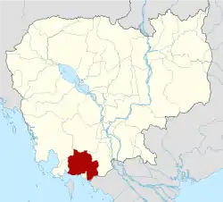 | |
| Places | ||
| Autonomous municipality |
| ||
|---|---|---|---|
| Provinces | |||
10°36′N 104°10′E / 10.600°N 104.167°E
This article is issued from Wikipedia. The text is licensed under Creative Commons - Attribution - Sharealike. Additional terms may apply for the media files.