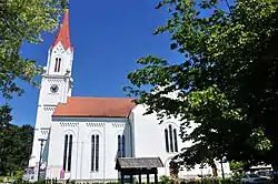
Wallern an der Trattnach | |
|---|---|
 | |
 Coat of arms | |
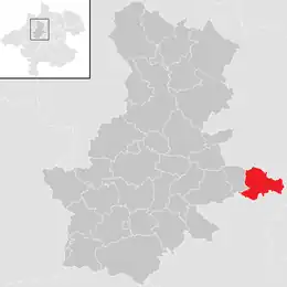 Location in the district | |
 Wallern an der Trattnach Location within Austria | |
| Coordinates: 48°13′54″N 13°56′55″E / 48.23167°N 13.94861°E | |
| Country | Austria |
| State | Upper Austria |
| District | Grieskirchen |
| Government | |
| • Mayor | Franz Kieslinger (ÖVP) |
| Area | |
| • Total | 14.63 km2 (5.65 sq mi) |
| Elevation | 298 m (978 ft) |
| Population (2018-01-01)[2] | |
| • Total | 3,039 |
| • Density | 210/km2 (540/sq mi) |
| Time zone | UTC+1 (CET) |
| • Summer (DST) | UTC+2 (CEST) |
| Postal code | 4702 |
| Area code | 07249 |
| Vehicle registration | GR |
| Website | www.wallern.ooe.gv.at |
Wallern an der Trattnach is a municipality in the district of Grieskirchen in the Austrian state of Upper Austria.
Geography
About 10 percent of the municipality is forest, and 76 percent is farmland.
References
- ↑ "Dauersiedlungsraum der Gemeinden Politischen Bezirke und Bundesländer - Gebietsstand 1.1.2018". Statistics Austria. Retrieved 10 March 2019.
- ↑ "Einwohnerzahl 1.1.2018 nach Gemeinden mit Status, Gebietsstand 1.1.2018". Statistics Austria. Retrieved 9 March 2019.
Wikimedia Commons has media related to Wallern an der Trattnach.
This article is issued from Wikipedia. The text is licensed under Creative Commons - Attribution - Sharealike. Additional terms may apply for the media files.