Wazirabad
ضلع وزیر آباد | |
|---|---|
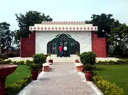 Tomb of Maulana Zafar Ali Khan | |
| Country | |
| Province | |
| Division | Gujrat |
| District | Wazirabad |
| Tehsil | Wazirabad |
| No. of Union Councils | 12 |
| Municipal status | 1867 |
| Area | |
| • District | 1,206 km2 (466 sq mi) |
| Elevation | 215 m (705 ft) |
| Population | |
| • District | 830,396 |
| • Density | 690/km2 (1,800/sq mi) |
| Demonym | Wazirabadi |
| Time zone | UTC+5 (PST) |
| • Summer (DST) | UTC+6 (PDT) |
| Postal code | 52000 |
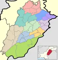
Wazirabad District (Punjabi and Urdu: ضِلع وزیر آباد), is a district that is a part of the Majha region in Punjab, Pakistan. Wazirabad District is bordered by the districts of Gujrat, Sialkot, Mandi Bahauddin, Hafizabad and Gujranwala.[2]
Administration
Wazirabad is in fact a City district. The district is divided into the following tehsils:
Demographics
| Year | Pop. | ±% p.a. |
|---|---|---|
| 1951 | 217,197 | — |
| 1961 | 254,715 | +1.61% |
| 1972 | 370,310 | +3.46% |
| 1981 | 442,493 | +2.00% |
| 1998 | 644,233 | +2.23% |
| 2017 | 830,272 | +1.34% |
| Sources:[3] | ||
At the time of the 2017 census, Wazirabad district had 128,515 households and a population of 830,272. Wazirabad had a sex ratio of 1033 females per 1000 males and a literacy rate of 75.50% - 77.88% for males and 73.26% for females. 299,713 (36.10%) lived in urban areas. 202,242 (24.36%) were under 10 years of age.[4]
At the time of the 2017 census, 97.55% of the population spoke Punjabi and 1.30% Urdu as their first language.[4]
References
- ↑ "PAKISTAN: Provinces and Major Cities". PAKISTAN: Provinces and Major Cities. citypopulation.de. Retrieved 4 May 2020.
- ↑ "Punjab CM approves establishment of four new districts in province". Daily Times. 2022-10-15. Retrieved 2022-10-15.
- ↑ "Population by administrative units 1951-1998" (PDF). Pakistan Bureau of Statistics.
- 1 2 3 4 "District Wise Results / Tables (Census - 2017)". www.pbscensus.gov.pk. Pakistan Bureau of Statistics.